- source: Commission of the European Communities. Community
Support Framework, 1991-1993 Federal Republic of Germany
Agriculture and industry are not the only areas that contribute to high soil and water pollution. Inefficient waste water treatment plants have been sited as great contaminators in East Germany. Poor infrastructure, such as leaky pipes, contributed to the pollution levels by allowing untreated or poorly treated water to seep into the water table. The new German Länder are said to have the lowest potential water supply in Central Europe due to untreated water: 9.6% of the population is supplied either intermittently or permanently with low quality water.
Eastern Europe represented the extreme end of the environmental scale in terms of environmental controls. Policies were never in place to prohibit environmental damage in these countries. As Alan Berner commented in an article in the Seattle Times, "if East Germany did not exist, environmentalists would have to invent it. It is Brand X, the perfect contrast to demonstrate the dangers of ignoring growing pollution." Yet, the irony is that while western countries complained and pointed their fingers at eastern block contamination and pollution, they too contributed to it. For example, when the city of Hamburg ran out of space to dispose of their sewage, industrial and domestic waste their solution was to import it to East Germany. In their haste to export more than 500,000 tons of waste a year they forgot to mention that it contained dioxins, one of the most deadly substances know. Clearly, West German consumption contributed to East German environmental deteriorated.
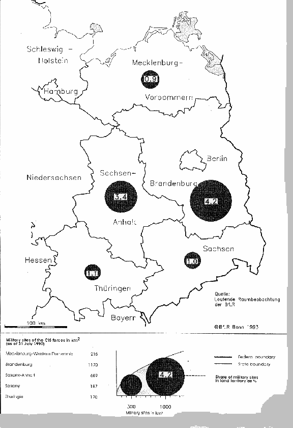
Russian Military Sites
Along with agricultural and industrial contamination, Russian military sites have proved to be major environmental liabilities for the new Länder. Approximately four percent of the total land in the former GDR was used for Russian military purposes. Map 4 shows the ratio of military installations to total land area by state. While there has been a recent trend to market the land for future development, land brokers have had a hard time selling the areas. Many Russian military personnel pulled out of East Germany as late as 1994. Up until that time westerners were denied access to examine the bases. Thus, three years ago, when Russian troops departed, the ramifications of environmental neglect were seen in full view. Highly contaminated military equipment and ammunition were found in most sites along with dilapidated buildings and infrastructure dating back to the Prussian area. Many buildings used by the Prussian army and then the Nazis, and were also occupied by the Russians.
The implications of these sites for the new Länder are important in terms of land use. The bases contain major environmental hazards, require extensive and costly cleanup and, unless they can be cleaned, represent unusable land. Brandenburg has the highest percentage of military sites. Estimates show that approximately 247,000 acres of military installations exist in this state. Some of the posts have been sold to investors and will be used for future developments, others are being slotted for future German military use. Yet, while many redevelopment plans have been proposed most cases are dropped when cleanup estimates are assessed.
Positive Trends
During the past 20 years many damaged ecosystems have proved they can regenerate if environmentally friendly practices are followed. The Rhine River provides an example of this theory. The Rhine was a highly contaminated river, but West German environmental policies markedly decreased its pollutant levels (Table 2). Pollution levels of East Germanys Elbe river in 1988 match those of West Germanys Rhine river in the 1970s. The linking of East and West Germany will promote a new transition period for eastern Germany. As environmental policies take shape, the ecosystem will likely begin to revive. While the results of this process will not be seen overnight, it is likely that many eastern German ecosystems can be regenerated and stabilized near their original state.
Table 2: Pollution on the Rhine and the Elbe, 1978 and 1988
| Elbe | Rhine | Rhine | ||
| 1988 | 1978 | 1988 | ||
| Volume of flow | m3/s | 874 | 2,455 | 2,836 |
| Ammonium | mg/l | 1.79 | 0.88 | 0.29 |
| Nitrates (NO3-N) | mg/l | 4.92 | 3.74 | 3.90 |
| Phosphorus | mg/l | 0.56 | 0.63 | 0.30 |
| Mercury | mg/l | 0.63 | 0.28 | 0.21 |
| Cadmium | mg/l | 0.37 | 0.23 | 0.13 |
Another positive trend in East Germany is that large parcels of the country are in good environmental condition with a rich diversity of species. This is a result of the relatively sparse and highly concentrated populations, and poor traffic infrastructure that did not allow for easy inner-country travel. The "no mans land " separating East and West Germany, along with state-owned hunting grounds created many natural untouched habitats. After reunification an emphasis was placed on preserving natural spaces, and by 1990 Nature Conservancy land increased in the new Länder from 0.98 percent of the total land to 2.5 percent of the total.
Economics
Communist polices toward housing and all types of business development has implications on present-day land development. While postwar West Germany development took place within the parameters of a market economy, the story of East Germany is different. Soon after WWII market forces in eastern Germany lost their importance as the government took over economic policies. The abolition of private ownership was the main program driving communist policies. Today, privatizing all former GDR companies is a major governmental thrust.
German reunification and the exposure of the East German economy to world has produced a profound adjustment period in the German economy. In terms of business investments which would bring in money for skilled labor, investors increasingly go further east to save on labor costs. East German wages have been raised to the level of wages in the west, thus giving them higher wage rates than their former communist neighbors to the east. At the same time housing stock and infrastructure have not caught up to western standards. These two issueshousing and wageshave been major inhibitors for investors looking to relocate in the eastern part of the country. It is in instances such as these where East Germany has not benefited from unification with the west.
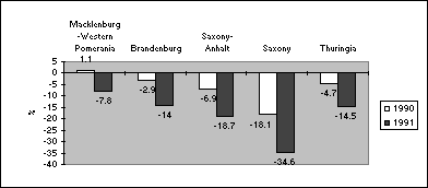
Further exacerbating this problem is the fact that between 1990 and 1993 business registrations decreased and business closures increased. The data available through the first five months of 1993 show that a degenerative ratio gets stronger through time (Figure 1). For example, in 1990 closures represented about 10% of registrations. This figure increases to a approximately 56% in 1992, and 62% between January and May 1993 alone. The breakdown in jobs has resulted in a drastic loss of employment. Unemployment in the new Länder rose to more than 1 million in the end of 1992, representing an unemployment rate of 16.5% where it remained through part of 1993. In fact, all of the economic sectors, except for building and construction, have witnessed job losses.
Figure 1: Registration and closure of businesses in the new German Länder, 1990-1993
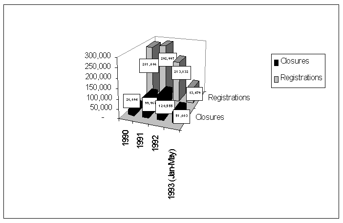
source: European Commission study, p. 5
Privatization
In spatial terms, privatization of state-owned enterprises influences investor's willingness to relocate business in the former GRD. In 1989 the State Trust Agency (Treuhand) was established to begin privatizing state-owned enterprises in the former GDR. By April 1992, 7,100 of the 11,500 enterprises existing in the new Länder had been privatized. While this accomplishment and many others can be applauded, two items have dimmed the achievements of the Treuhand: 1) they have inherited lots of debt; and 2) many of the newly privatized enterprises are not able to fulfill commitments to the Agency in areas such as jobs preservation.
Spatial Change in the new and old Länder
The desire for economic progress plays an important role in German land development. In post-WWII Germany an economic upswing occurred when the cities experienced growth outside the Altstadt (old city). For example, the town council of Hassfurt, West Germany designated the outer regions of the city as commercial zones. Car dealerships were among the first to move to these areas, followed by gas stations and in the 1970s other retailers. Inexpensive land helped to promoted this type of greenfield development. Today the outcome of this trend is that large retailers and supermarkets, often discounters, are interspersed between German towns. Germans refer to these commercial type strips and their architectural style as "little Americas". The implications of this type of growth are significant. Not only do these new developments demolish existing land, but funding and land resources are spent on new infrastructure and road construction.
Today the new Länder are mimicking West German growth patterns. When the Wall fell, western chains were convinced they would have an easy time establishing businesses and making a profit in eastern bloc countries. High demand, lax enforcement of building codes and zoning, and little local opposition reinforced these theories. The unstoppable spread of retailers has created developments on what is known as greenfields, which consist of large malls located between communities. Often community governments in the east have bowed to development pressures in order to please voters and raise revenues.
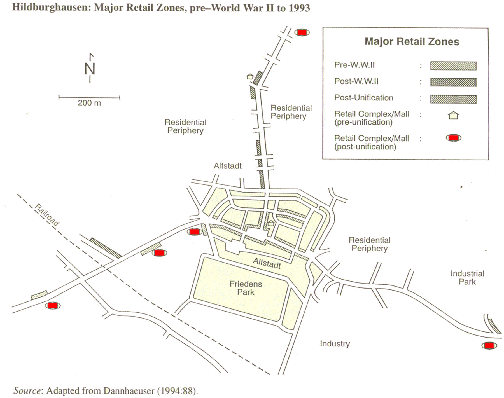
Demand and market forces have continued to lead growth patterns. At the time of reunification the density of retail facilities in a typical East German city was half that of other German cities. In the city of Hildburghausen, a former GDR city, thirty new enterprises were established by August 1991. Even more dramatic was the increase in retail space which doubled in this short time from 5,000 sq. meters, to 10,000 sq. meters. Exacerbating this rapid development are laws created to provide incentives for German investors to write off 50% of their additional investment beyond the purchase price of the land. Map 5 shows how the city of Hildburehausen is being reshaped because of rapid growth on the periphery of the city. Not only will the growth build on existing green space, but the cost to the government and citizens for infrastructure to these areas will be enormous.
Contributing to eastern Germanys spatial change are commuting patterns. According to a survey done by the Institut für Arbeitsmarkt und Berufsforschung der Bundesanstalt für Arbeit (IAB) in May 1992, 63% of Germans living in the new Länder commuted to western Länder. More significant are the distances commuters were willing to travel to reach places of work. Along the East German border many of the commuters live and travel from 40 to 60 km one way. As transportation systems are improved and built in the east, more land and autos will be in demand.
The states in the former East Germany are experiencing different rates of progress. The northern most state of Mecklenburg-Western Pomerania is experiencing the most severe structural problems among the new Länder. Its weakness lie in the fact that it had traditionally high shares of farming and low shares of manufacturing compared to other Länder. Uneven regional distribution of industrial locations coupled with poor internal transportation infrastructure has also posed a disadvantage for the state. Job losses in the farming and fishing industries, and collapsed industrial sites have left this state with the highest rate of unemployment in all of Germany. The job sector is not diverse and thus, alternative employment opportunities are not available in this area. On the other hand, Saxony has a diversified economy with an industrial sector characterized by large-scale enterprises and the industrial sector evenly distributed throughout the region. The transportation links in this area have been considerably updated since reunification. The difference in these two states points out some of the internal stress the former GDR Länder are experiencing in terms of economic and spatial growth.
Population
Since the 18th Century, European population has increased primarily as a result of natural population growth, specifically births rapidly exceeding deaths. By the end of the Second World War, birth rates in Europe began to drop below the death rates, signifying what has been described as a "second demographic transition, very different from the first". As Maria Carmen Faus-Pujol states, "rather than an increase in population, this is characterized by stabilization or even a reduction of the population, and the demographic factor responsible for this trend is the fall in the birth rate." The birth rate in Western Europe was the lowest of any major bloc in the world in the beginning of the 1990s.
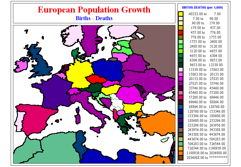
Germany (both east and west) has been experiencing this post-WWII population decline, particularly in the last thirty years. Significantly, Germany has one of the slowest growth rates in all of Western Europe (Map 6). While some argue that a transition is occurring where all western, industrialized countries will start to experience negative growth rates, others claim that it can no longer be said that the countries are converging on a common growth rate pattern because of the varying social and economic conditions in each country. If the first hypothesis is true, it can be assumed that Germany is reaching a demographic transition stage sooner than other European countries. Otherwise it can be assumed that German population increases are purely a factor of social, cultural and economic change. Whatever approach is taken, it can not be denied that Germany has a decreasing population trend. The countrys slow population growth rate can be explained by industrialization, urbanization, high amounts of educated women in the work force, and low birth and high death rates. Attitudinal changes, such as secularization, egalitarianism an emancipation, are also often cited as contributing to this change.
It is important to note that of all the European countries, including the former east bloc and Russia, the only other countries experiencing a negative or even growth rage are Bulgaria and Hungry (Map 6). It is interesting to note that Germanys economic and population structures are much different from Hungry and Bulgaria. While the countries are relatively close in proximity and are experiencing the same population trends, their negative feedback indicators may not be similar. Hungary has experienced a transition in the last decade that reflects its population decline. A gradual shift towards older ages coupled with high death and low birth rates has driven this pattern. Contributing to the high death rates in this country is the poor health care system. It is stated that mortality rates for middle-aged men in Hungry are possibly the worst in the world. Bulgaria, on the other hand, has experienced a population change that has favorably more women than men (in 1995 the ratio was 1,041:1,000). Also compounding their population decline is the considerable rate of emigration. Between 1989 and 1994 450,000 people left Bulgaria. Despite a relative lull, estimates show that currently nearly 25,000 continue to emigrate every year. David Coleman also points out that, "in view of the political uncertainty and serious economic disruption these countries have undergone, this (low fertility) is hardly surprising; the least developed areas and those undergoing the most radical change, have shown the greatest decline".
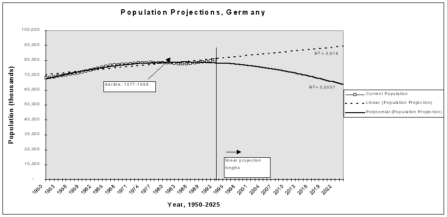
The decline in population growth experienced in the whole of Germany began in the mid 1970s. Starting in 1950, population increased at a rate of less than one percent per year (Appendix 1). Looking at the population growth graphically (Figure 2), one can see that growth has been extremely slow (data in this series is both East and West Germany combined). As previously stated, post-WWI European countries experienced low growth rates. The 1950s and 1960s data relay the short baby-boom in West Germany, but then the population begins to level out again only to drop in the mid-1970s. Figure 2 shows a slight rise in the population after 1984 (perhaps explained by economic boom or immigration patterns) only to increase by approximately .5% every year. While this data shows a minor increase, similar data sets show decline or stabilization in the population structure (Figure 3).
Figure 2
source: WRD, see Appendix 1 for calculations
Figure 3
source: Council of Europe, Recent Demographic Developments in Europe, 1996
In Figure 3 a decline and perhaps slight stabilization can be seen. Given this information, Figure 2 also calculates two types of population projections: linear and polynomial. The linear equation accounts for population increases, while the polynomial projection mimics a declining population. It is interesting to note the R2 factor in both projections, specifically that the polynomial projection has a higher R2 than the linear (linear, .814; polynomial .9558). If the linear projection is correct, Germanys population will be around 90 million by 2025 while the polynomial projection predicts a population of around 65 million. Interestingly, UN population projections predict German population at a high of 76,566,000, and a low of 66,062,000 by the year 2025.
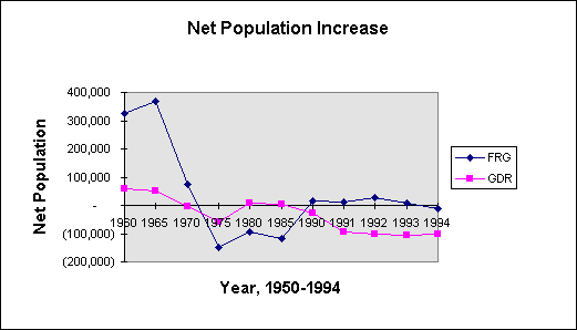
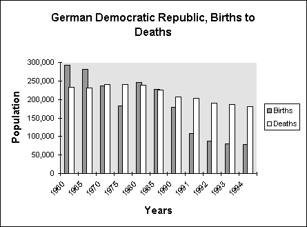
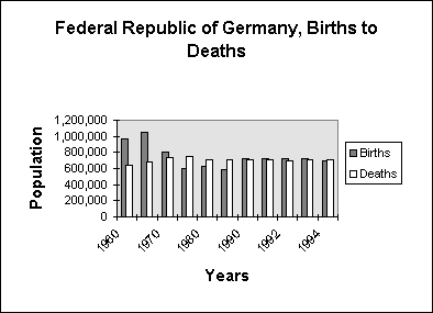
Another way to examine the population trends in Germany is to divide the data by East and West Germany. Figures 4 and 5 show the birth and death rates compared. In the GDR almost consistently since the 1970s deaths have outweighed or almost matched births. On the other hand, West Germany has experienced an almost even equalization of the populations' birth to death rates. In terms of demographic transitions this data proves that the GDR is still experiencing a transition and perhaps will level out to the population levels of the west. The FRG, on the other hand, has experienced almost consistently even birth to death rates. As the new Germany stabilizes socially and economically their population rates may change. It is my conclusion that population rates will continue to decline slightly or remain constant.
Figures 4 and 5
source: Council of Europe, Recent Demographic Developments in Europe, 1996
Eastern Germany
Since the Second World War fertility patterns in the former eastern bloc countries have developed somewhat differently than those in the west. Specifically, countries in eastern Europe did not experience the same baby boom period in the 1950s and 1960s (see Figure 4). As David Coleman points out, "in these countries the general transition to very low fertility, and major fluctuations such as the baby boom, which might have occurred under a post-war free market system, have been retarded or suppressed by various aspects of the communist system." Specifically, limited autonomy and spending, little satisfactions outside the family and limited access to contraception are some the issues cited. Stress on the population, specifically the post war period of the 1950s and the closing of East Germany to the west in 1961 could also account for this dip in population.
Communist regimes depended on high growth rates as a means to support economic prosperity. As a way of promoting higher birth-rates many countries offered positive incentives in the form of financial assistance to families with children, or bonuses such as year long maternity leave for mothers. Nonetheless, in the 1970s deaths outweighed births, and in the 1980s the crude numbers are almost equal. Some of the negative feedback indicators that contributed to this decline were political instability and upheaval, women joining the workforce, urbanization, poor housing stock, poor living conditions and minimal outmigration.
Rapid urbanization is often cited as an indicator for population decline. Table 3 cites how the trend in higher urbanization patterns can be a factor contributing to lower growth rates.
Table 3: Urban Population and Live Births, 1960 and 1985
| 1960 | 1960 | 1985 | 1985 | |
| Percent of Population in Urban areas | Live Births per 1000 | Percent of Population in Urban areas | Live Births per 1000 | |
| GDR | 72 | 17.0 | 77 | 13.7 |
| Czechoslovakia | 57 | 15.9 | 74 | 14.5 |
| Soviet Union | 50 | 24.9 | 66 | 19.4 |
| Poland | 48 | 22.6 | 60 | 18.2 |
While the GDR has experienced the highest percentage of urbanization, it had the lowest birth rates of all the eastern block countries. These numbers are indicators of how interrelated urbanization and birthrates are for various countries.
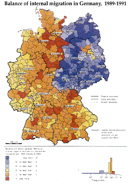
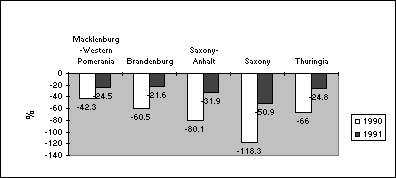
After the fall of the Wall, population in eastern Germany experienced large numbers of outmigration caused by labor markets, economic and social factors in the east. Between 1989-1992, each state in the new Länder lost over 1 million people. Map 7 shows the internal migration patterns from 1989-1991. This map clearly depicts the one-way migration patterns from the east to the west. Yet, it should be stated that compared to natural population movements, outmigration plays a diminishing role in eastern Germanys population development, and has continued to decline since the fall of the Wall. A more significant population change factor is the drop in the net population. As stated in a 1996 European Commission study, "since the breakdown of the former regime the number of live births has drastically decreased by almost half and stabilized at this low level." Figures 6 and 7 break down East German population by State, and clearly depict how outmigration, and birth and death rates of each eastern German state figure in to eastern German population loss/gain.
Figure 6
Natural population movements and migration in the new German Länder, 1990 and 1991
source: European Commission Report, pg. 32
Figure 7
Live births in relation to mortality in the new German Länder, 1990 and 1991
source: European Commission Report, pg. 32
This decrease in population growth might be explained by the fact that many people migrating out of the country are younger people looking for work. Older portions of the population, those people that have lived in a city for decades, may not have the means or desire to move away. Thus, an older population is left in the country, which statistically means greater deaths over births.
Case Studies
Berlin
As a future and once former capital, Berlin has always been a center for commerce, government and living. In many ways, East and West Berlin reflect on a micro-scale the events occurring in land use development in other parts of Germany. Investors saw great opportunities in Berlin with the fall of the Wall. Estimates for services demanded in the east, as well as speculations on whether the government would reclaim Berlin as the capital of Germany, became motivating forces for developers. These factors coupled with the fact that the city (both east and west) did not have a comprehensive land use plan encompassing both areas compounded land development plans. Until 1994, when the official post-reunification land use plan was approved, there were no legally binding laws prohibiting building in the area of former East Berlin and in the no mans land which made up the buffer area between the two cities. Thus, the first years after the fall of the Wall Germanys detailed land use planning structure fell apart.
Much of the land interests focused in East Berlin and in the areas around the undeveloped "no mans land" between east and west. Investors jumped at any opportunity available to buy-up and develop these areas, and many pressed their plans to be passed believing it was not politically or economically feasible to wait for a uniform land use plan to be developed. Consequently, before the master plan of 1994 was completed, quick land use decision in the west were made in the Berlin Senate, while in the east a Federal Building Code was created to restrict rapid building by predicting how closely a new development would exist harmoniously within the immediate surroundings. These two mechanisms were able to be kept many projects at bay.
Plans for new and improved retail space in the east became a hot topic among investors and developers. Statistics show that when the Berlin Wall fell, 78 % of all shopping floorspace was in the western sector, thus developers immediately jumped in and added more retail space to the citys eastern side. Today retail outlets have been augmented in the core area of East Berlin, yet current trends show that Berlin city authorities want to plan "polycentral" shopping areas. This trend will speckle shopping centers throughout the city and surrounding areas, rather than reinforcing the traditional single city center structure found in older European cities. The concern with this trend is that it conclusively has pulled economic growth away from the center city.
Another important land use development pattern to consider in Berlin is the tradeoff between office and industrial space expected to occur in the next few years. As the federal government moves to Berlin, industry is expected to leave the city. Between 1961 and 1989 West Berlin was a heavily subsidized city. Industries that located in West Berlin were at a disadvantage because of their distance from markets in the west, thus subsidies provided incentives for these companies to stay in the city. Today subsidies are available to industries that wish to move outside the city and into the territory of the former east. According to a survey carried out by the Deutsches Institut für Wirtschaftsforschung in 1992 10% of all companies active in Berlin intend to relocate to out of town areas around Berlin/Postdam. The movement of these companies into the Brandenburg countryside will mean heavier traffic patterns as well as environmental damage as new growth envelopes existing land.
Office space and housing have become another key factor in spatial development. With the seat of the government moving to Berlin, it is estimated that by the end of the decade 108 million square feet of new office space will be added to Berlin alone. Housing shortages, exploding rents and property prices, and poor quality housing stock in the east are expected to push development further into the periphery of the city.
The problem with trying to control both the industrial and housing growth is that there is no regional oversight board. When it comes to Berlin, the principles of post-war West German land use planning fall apart. Berlin is an island in the middle of the state of Brandenburg. The municipalities in Brandenburg, exercising their new powers, want development in their areas. Enticing developers to come is not hard: planning permissions in these areas of the east are easier to obtain than in Berlin. American style megamarket developments are already appearing in these areas.
Policy Recommendations
When evaluating the present prosperity gap between eastern and western Germany, and in light of recent economic figures, many assume that the new Länder will not match the standards of living of the old Länder any time soon. Some estimates project that this equalization will take place at the earliest by 2005 while others believe that eastern Germany is doomed to have a sluggish economy which will never catch up to the west. Nonetheless, policy trends will surely try to remedy this situation through interventions which seek to: 1) decrease deficits; 2) cleanup and improve the environment; 3) reform administrations; and, 4) invest in infrastructure.
The Case for Regional Planning
Regional planning is a vital tool that can be used to assist in German spatial planning. Regional planning should be established at three levels: 1) within the Länder between the various municipalities; 2) among the Länder; and 3) between Germany and their neighboring countries particularly Poland and the Czech Republic. By establishing economic and environmental goals and objectives, all three areas of regional planning could be used to reduce environmental degradation and increase efficiency in development. The border areas in eastern Germany near Poland and the Czech Republic are of particular importance because of the immediate necessity for environmental cleanup and improved transportation.
It is critical that policy makers and planners focus on the entire country of Germany, both east and west and not isolate certain areas for development and improvement. Much attention has been placed on the growth and development cycles around Berlin and on the border of the former FRG and GDR. Yet, this emphasis ignores other areas in the east. Clearly, while situations in the new German Länder may seem uniform they are "by no means homogeneous." Each state and region differs greatly in terms of locational advantages and development potentials. For example, the border areas between eastern Germany and Poland and the Czech Republic are suffering greatly. German border cities loose jobs to the cheaper labor markets of their eastern neighbors. This pattern further depresses cities in this area. Compounding this problem is the poor transportation infrastructure leading to the western part of the country. Ultimately, further outmigration occurs leaving eastern cities more deserted and depressed.
An emphasis must also be placed on equalizing spending on German cities. While environmental cleanup and economic development in the east is crucial, it is important to recognize that problems of deforestation and growth still exist in the western part of the country. Critical to this concept is the reality that land in both the east and west is being developed at a faster rate than the population is growing. This American pattern of land development has significant implications. Germany must use caution when allowing developments to pop-up in the East. Although economic development is crucial, it would be more progressive and future-oriented for policy makers to insist on redeveloping existing space. The German government has initiated policies that encourage investors to rehabilitate buildings by giving tax benefits that allow investors to deduct renovations in full from taxable income within 10 years. But as Helmut Fleischhauer, real estate broker for in Hameln Germany pointed out, it is a real problem to get buyers excited about houses that are rundown to begin with. The competition is the greenfields that are considered more scenic, often less costly and easier to develop.
It is likely that policy makers will decide to create stronger transportation routes, which in turn will increase eastern German land value. Major routes will most likely be placed from larger western German cities (München, Hamburg, Düsseldorf, Frankfurt, and Stuttgart) to the main major eastern German cities (Berlin, Rostock, Dresden, Leipzig, Erfurt/Jena). While transportation infrastructure is necessary, it is important to keep in mind how these transit routes might affect eastern German cities. It will be crucial to make sure these cities in-between dont merely become transit routes but instead destination points for commerce and living. One idea would be for the country to create a transportation master plan which would strategically place all future major transportation routes.
Depending on the urban planning policies and strategies of the new German Länder the Russian military bases can be viewed as long-term deficits or locational assets. Planning measures can be initiated to clean sites through a phased plan over time, thus saving on cost. Also, land that is not highly contaminated can be made into regional parks with restored natural ecosystems.
Retail stores has continually led development in the new Länder. While it is important to have solid retail industries, Germany must pay attention to small businesses being shutout by this growth and must promote a diversity of business and industry to move into the areas. While retail is an important aspect to an economy, it is also a "soft" industry that is easily effected by any type of recession or economic slump. Thus, strong industries, which desire a skilled-workforce, should be enticed to move into the areas. Already the development frenzy has left many cities in the East with an over supply of retailers. The German Retail Association estimates one square meter of retail space is needed for every resident of a city. Yet, in many cities in the east the ratio of retail shops to inhabitants is well over 1 square meter per person.
Implications
Since the end of the Second World War, Germany has been a leader in
architecture, urban planning and environmental policy, striving to create
unique and feasible environmental alternatives and technically innovative
ways of living. This tradition has given rise to great experiments in architecture
and planning: the Werkbund, the Bauhaus, the Siedlung developments and
the post-war international building exhibitions. Strict environmental
clean-up policies as well as leading political parties like the Greens
have been upheld as examples for countries around the world concerned with
their ecosystems. Do current post-reunification trends indicate that this
legacy is about to end?
Land use patterns in both the east and west are mimicking American style,
suburban growth. While Germany has strict land use regulations, the chaos
following the fall of the Wall and the desire for improved economic conditions
in the east have led into development patterns which may hurt German cities
in the future. Development patterns indicates that land is increasing at
a much faster rate than population growth. In a recent article Robert Geddes
writes:
The process of German reunification has reached a critical stage. The regional disparities between eastern and western Germany are still enormous in terms of standard of living, employment, business activity, infrastructure and environmental conditions, with the people in the east undergoing grave social hardship and problems. The transfer of capital to the new German Länder, which is meant to spur their economy and to promote the convergence of living conditions in the two parts of Germany, places a heavy burden on the old Länder. Yet, while Germany is concerned with the rate in which economic conditions in the new Länder are catching up to the old Länder, they are allowing land development to rise at a faster rate than the population is growing. While the country historically has had relatively strict land development guidelines, they have allowed these rules to be flexed for the new Länder. If Germany wants to keep its position as a leader in the field of environmental policy and planning, and if the country is concerned with future growth patterns and the affects on the environment, they need to examine their current policies and create a vision for future land use and environmental planning.
Link to Appendix
Bibliography
- 1992 Agra Europe, "Environment a priority in restructuring East German farming." February 7, 1992, p. E9.
- 1993 National Trade Data Bank. "Germany: Housing Construction Market Profile". July 20, 1993
- 1995 National Trade Data Bank Market Reports. "Germany: Pre-fab Construction Project". March 22, 1995
- Balfour, Alan. Berlin: The Politics of Order, 1737-1989. New York: Rizzoli International Publications, Inc. 1990.
- Balfour, Alan. World Cities Berlin. London: Ernst & Sohn, 1995
- Berry, James and Stanley McGreal. European Cities, Planning Systems and Property Markets. London: E&FN Spon, 1995.
- Blanke, Bernhard, and Randall Smith editors. The Future of the Medium-sized City in Britain and Germany. London: Anglo-German Foundation, 1993.
- Brenner, Alan. The Seattle Times, November 13, 1990.
- Carter, Erica. How German Is She? Michigan: The University of Michigan Press 1997
- Coleman, David. Europes Population in the 1990s. New York: 1996
- Commission of the European Communities. Community Support Framework, 1991-1993
- Federal Republic of Germany. Luxembourg: Office for Official Publications of the European Communities, 1991.
- Council of Europe. Recent Demographic Developments in Europe. Belgium: Council of Europe Publishing, 1996.
- Dannhaeuser, Norbert. Two Towns in Germany. London: 1996.
- Diefendorf, Jeffry. In the Wake of War: the Reconstruction of German Cities after World War II. Oxford: Oxford University Press, 1993.
- Drake, William. Towards Building a theory of Population-Environment Dynamics: A Family of Transitions.
- Estate Times. "Germany: Berlin Promotes East for Shops". November 24, 1995
- European Commission--European Union, Regional Policy and Cohesion. The spatial consequences of the integration of the new German Länder into the Community. Luxembourg: 1996.
- Fleischhauer, Helmut. Real Estate Broker, Hameln , Germany. Email communication from October 21, 1997.
- Geddes, Robert. "Metropolis Unbound," The American Prospect Journal 35 (November/December 1997), 40-46. The German Institute for Economic Research (DIW). GDR and Eastern EuropeA Handbook. Trans. Eileen Martin. Vermont: Gower Publishing Company, 1989.
- Gray, Robert. Estate Times, "Germany: Estates Times ReviewBusiness Parks; Assessing Development Porposals. June 26, 1992
- Gutman, Roy. Newsday, "Developers Ignore Nazi Infamy". August 11, 1991.
- Hall, Ray and Paul White editors. Europes Population: Towards the next century. London: UCL Press, 1995.
- Herf, Jeffrey. The American Association for the Advancement of Science, "The Environmental Movement in Germany: Prophets and Pioneers, 1871-1971book review:" vol. 260; no 5112, pg 1353.
- Kinzer, Stephen. The New York Times, "A Cold War Ruin, but With Potential". August 14, 1995, p A-5.
- Koenig, Robert. The Journal of Commerce, "Former Soviet Bases in Germany for Sale, Maryland Developer Returns to Stake Claim." June 13, 1996.
- Koenig, Robert. The Journal of Commerce, "Spotlight on East Germany". November 19, 1996 p 6A.
- Manser, Roger. Failed Transitions. New York: The New Press, 1993.
- Morais, Richard C. Forbes, "The Berlin Bubble". Forbes, April 8, 1996 p. 78-79.
- Newman, Peter and Andy Thornley. Urban Planning in Europe. London: Routledge, 1996.
- Organization for Economic Co-operation and Development (OECD). OECD Environmental Performance Reviews. Paris: 1993.
- Payton, Jack. The St. Petersburg Times, "Building boom echoes in Berlin". November 16, 1996, p 2A.
- The San Diego Union-Tribune, "West Germans dump garbage issue on courts". December 25, 1986, p. A-16.
- Shirreff, David. Euromoney Publications PLC 1996, "Real-estate Role-coaster". April 1996 no. 324, p 53.
- Top-Invest International, Real Estate Investments. http://www.top-invest.com/germany/info.htm
- Viviano, Frank. The San Francisco Chronicle, "Big Soviet Bases are a German Headache
- Unwanted windfall as Red Army leaves." September 21, 1993.
- Walsh, Mary Williams. The Los Angeles Times, September 3, 1994, p. 2-A
- Woodruff, David and Miriam Widman. Business Week, he East is Still a Mess". June 19, 1996, p 24.