 |
 |
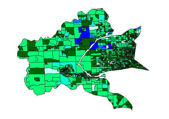
GIS Population map for the Huron and Rouge Watersheds
|
|
|
This map shows the ranges in actual population in block groups for the Huron and Rouge River Watersheds. There are several points which are interesting to note here. First, there is little blue where you might expect to find it most, near Detoit (the eastern edge of the Rouge Watershed). This is because block groups are divided based on density. Since this area of the Watershed is the most densly populated, the block groups are smaller. Therefore, the total population within each of these minor devisions is rarely larger than 3,000 people. Secondly, it is also worth noting the large blue blocks that are near the Northville area. These blocks have not yet beeen split up into smaller blocks. With the major suburban migration into this area the numbers have increased while the density at the time this data was collected was still small enough for a large block like this to exist.
The population of the Huron Watreshed is considerably less than that of the Rouge Watershed. When this map is compared to the map for Land Use, it becomes apparent that the larger, less dense, block groups of the Huron Watershed coincide with the large amounts of agricultural land in this watershed.
The biggest problem these two watersheds have today are the
increasing
populations within their borders. The increase in populations
means
greater stress on the already overloaded Detroit sewer system. As
more and more development occurs within the watershed, more and more
connections
are made to a sewer system that was never designed to handle the volume
of water it now has to carry. This equates to a lower threshold
for
combined sewer overflow. The rains that might have not caused the
sewer system to overflow in the past, are now pushing the systems
carrying
capacity, causing overflows to happen with less sever storms. FOr
more information on combined sewer overflow (CSO), visit the Friends
of Rouge homepage.