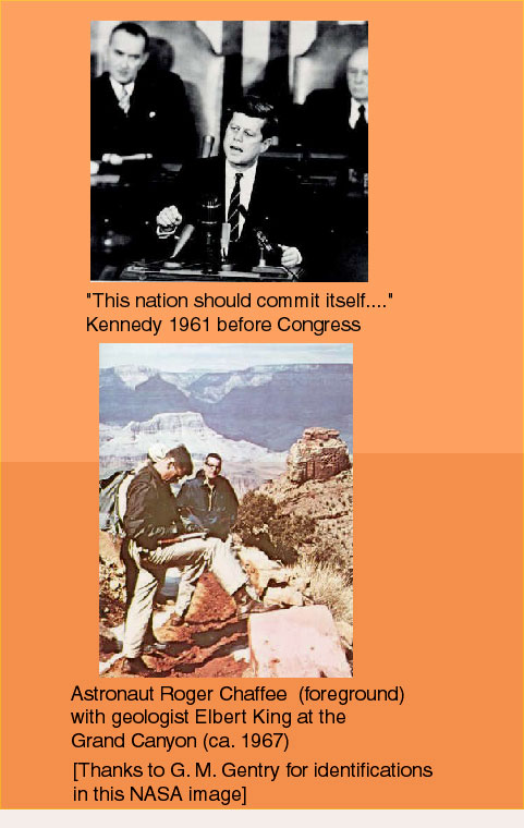
Until the 1960's only a few prescient individuals thought of the Moon
and the terrestrial planets as objects like the Earth. Then, because
of the race to put men on the Moon, the time for this approach had
come. Scientists began to apply well-established principles of Earth
science, first to the Moon, and then to Mars and Mercury. A new
dimension of planetary science was opened. It had been there all along,
of course, but the scientists were as usual
mostly confined to their little cubbyholes of
speciality. The idea had to await its time.
The advent of this new dimension was reflected in the language. People began to speak of astrogeology, planetary geology, or simply planetology. A new breed of scientist joined the investigation of celestial bodies--those with a firm background in Earth science--and the discipline was immensely enriched.
It had happened only a short time before. Immediately following the close of World War II, electrical engineers with backgrounds in radar, opened the radio window to the universe, adding such things as quasars and the cosmic background radiation to the classical astronomer's universe.
In this essay, we will describe some fundamental methods of planetary geology for the interested layperson. We couldn't find a better place to illustrate the geological ideas than the Grand Canyon. Here many of the layers of the Earth's history are plain to see. Equally fascinating are the missing layers, where the history is unavailable. We will get to them later. For the present, hold this thought: the planetary geology that we emphasize here is concerned with history. Of the four physical sciences, astronomy and geology share a historical dimension that is absent in chemistry and physics. One of the more important tools used by planetary scientists to enter this dimension is geological mapping using standard stratigraphic principles. We will illustrate them with the help of images from the Grand Canyon.
A new (July 2002) web site describes geological methods and their application to the history of a region in southern New York state. The site has many illustrations, links, definitions, and tutorials.
The application of these principles to the Moon and planets began in earnest with study of lunar features, by the geologist Eugene Shoemaker (1928-1997). Before we discuss his work, we must review some basic ideas.
Selenology is a somewhat old-fashioned word that means the study of the origin and history of lunar features. Today, almost no one uses the term selenology. Instead, it is common to speak of lunar geology, or more generally, planetary geology.
Until the middle of the 20th Century, about all that could be done with lunar features was to photograph and classify them, and give them names. There was no general agreement about the nature of these features, but there were two main theories. The lunar features were either volcanic in nature, or caused by impacts of meteoroids. Interestingly, the theories were rarely mixed. Advocates of the impact theory sought to explain the maria in as oceans of small ejecta. Advocates of volcanism, had the right explanation for the maria, lava flows, but were mostly wrong about the craters themselves.
Only in the years immediately following World War II did it become clear that the lunar craters were created by explosive impacts rather than volcanic activity. Since the lunar surface is dominated by craters spanning a huge spectrum of sizes, we could not know much about the Moon until we realized what these craters were. While many names are associated with the impact theory for the origin of lunar craters, perhaps the most influential was Ralph Baldwin, a graduate of the University of Michigan, and PhD from its Astronomy Department. We must leave a discussion of Baldwin's contribution to references. We recommend Don E. Wilhelms's To a Rocky Moon: A Geologist's History of Lunar Exploration (Tucson: University of Arizona Press, 1993). This is a good source for the work of Baldwin, and for much of this essay.
Soon after the nature of the craters were clarified, true lunar geology could begin. Much of the work was done by employees of the US Geological survey, with (for them) standard geological techniques. Until the return of lunar samples, the analysis was largely by the principle of superposition. This is a refined version of common-sense notions: a layer on top is younger than layers beneath it; if a rock wall if fractured, the wall is older than the fracture, and if a vein passes through a rock, the vein is younger than its host. The principle of superposition was recognized centuries ago.
In the case of the Moon, one couldn't see veins in the rocks from the Earth, and any layering one could make out was pretty rudimentary. Nevertheless, some history was plain to see. Craters were seen to destroy the rims of other craters, so the craters with the damaged rims were surely older than those that destroyed their rims.
Impact craters are surrounded by blankets of material ejected in the explosions, and in some cases these ejecta form a system of bright, radial rays. The brightness of the rays associated with the ejecta varies from crater to crater, fading to indistinctness. It was readily seen by careful examination that the rays of some craters cut across and obliterated the rays of others. A crater whose rays were cut or distorted by another was clearly the older of the two, and it was immediately found that the brightness of the rays was an indication of crater youth. Young craters had bright rays.
The Principle of Superposition gives only relative ages. These relative ages were about all that the 18th and 19th century founders of modern geology had to work with. Until the return of the Apollo samples, the same was true for the Moon. Since the scientists could not date geological materials chronologically, they gave them names. These names have been the bane of many a student of introductory geology: Why not just say a layer is 70 million years old, rather than saying it is Cretaceous? The reason is that the people who assigned certain geological materials to the Cretaceous did not know how old they were.
When terrestrial materials can be dated by radioactive techniques, they may be placed into one or another of geological time units. The largest of these units is the Eon, and it has become generally used only in the latter part of the 20th century. The reason for this is fairly straightforward. While it has been known that the Earth is between 4 and 5 billion years old for a century, only the most recent half billion years has been studied in detail. This is because fossils, which are still used as indicators of the age of geological layers, are virtually nonexistent in rock layers older than about 570 million years (roughly half a billion years).
Intensive searches for the existence of life before this time have revealed traces of living cells well before the once-impermeable veil some 570 million years back. The record for fossils at the time of this writing is 3.5 billion years ago. The story of the discovery is told by William Schopf in his book Cradle of Life. There is indirect evidence, from carbon isotopes, that life forms were present on the Earth as early as about 4 billion years ago. The oldest Earth rocks are hardly older than this.
These findings make it meaningful to divide the Earth's history into time chunks called Eons, of the order of a billion years. Prior to the introduction of the Eon, the largest division was the Era, with time divisions of the order of a hundred million (0.1 billion) years. There is an exception to this. The Pre-Cambrian Era included all of the time from the Earth's beginning to a time 570 million years back, so it spanned some 4 billion years!
The next two divisions of geological time were respectively the Period and the Epoch, characterized by intervals of the order of several tens or several million years respectively. Table 1 is a summary. Remember that 100 million years is 0.1 billion years.
| Unit | Example | Approximate Duration |
|---|---|---|
| Eon | Phanerozoic | 1-2 billion years | Era | Cenozoic | 100 to 300 million years, except for Pre-Cambrian |
| Period | Quaternary | 10 to 100 million years |
| Epoch | Pleistocene | 1 to 10 million years |
Geologists typically illustrate the divisions of time with the help of block-type diagrams that they call ``the geologic column.'' In Figure 1, we illustrate the two biggest time divisions. Recall that eons were not widely used until the end of the 20th century. This was primarily because geologists had relatively little data on this the largest of the eras. While this is still the case, sufficient information is available that the more uniform divisions, the eons, have come into general use.
Figure 1: Eons and Eras

The oldest and largest of the eras, the Pre-Cambrian, takes its name from the oldest of the smaller time division, the Period. Periods and epochs are shown in Figure 2.
Figure 2: Periods and Epochs
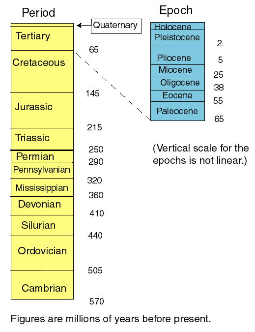
The columns illustrated in Figures 1 and 2 have definite times associated with the different names and divisions. This was only possible after radioactive dating came into use near the beginning of the 20th century. What did 19th-century geologists do? The answer is that they used the principle of superposition and relative ages. A number of the names of Figures 1 and 2, especially of the more recent periods and epochs, appeared in the classic text of Charles Lyell (cf. vol. III, Table II, 1833). Lyell had the relative order correct, and some of the terms that he used are still employed, sometimes with different meanings.
Geological systems, and series mean very nearly the same as periods and epochs. For most purposes, one need not distinguish the meanings. The names of geological eras and systems are usually the same. Thus we have the Jurassic system and the Jurassic period, which most laypersons may be excused for using interchangeably.
Geological materials (layers, rocks, lava flows, etc.) are assigned to systems or series on the basis of properties other than radioactively determined dates. For example, one may use the principle of superposition, or the fossil content of limestone layers. Thus 18th and 19th century geologists could (and did) map the surface rocks into systems and series. Some noble efforts not withstanding, they did not have the means to assign absolute times.
This is the situation that applies to every planetary surface (ca. 2000) other than those of the Earth and Moon. Indeed, lunar systems and series were delineated prior to the return of the Apollo samples, as we discuss momentarily. Even though it is now possible to apply absolute ages lunar maps still refer to systems.
The reader who wishes a thorough tour (in bewildering detail) through stratigraphic nomenclature, may consult the url: http://www.agiweb.org/nacsn/code2.html#Article72. We shall simplify the classification with the help of the following table. Entries in parenthesis are rarely used, and may be ignored by all but the experts.
| Rank | Geological Time Units | Chronostratigraphic Units |
|---|---|---|
| 1 | Eon | (Eonothem) |
| 2 | Era | (Erathem) |
| 3 | Period | System |
| 4 | Epoch | Series |
One more set of words used by terrestrial and planetary geologists needs to be discussed. Geological materials that are less closely related to time are classified into groups or formations. The group is the larger division, and may contain several formations. These rock stratigraphic units may have additional divisions that we will not need here. The units are distinguished from one another directly by the materials themselves. The connection with time may be immediate and obvious, as will be the case with some of the formations that we shall discuss for the Grand Canyon, or they may not be.
One example of a stratigraphic unit that may cut across time boundaries is that of the sandy beach of an evaporating sea. If the sea slowly evaporates or drains, beach sand will move from the outer boundary of the young sea to successive inner peripheries. The compacted beach sandstone may be uniform in appearance, and yet cut across a wide range of geological times.
The Grand Canyon layers are most often referred to as groups or formations even though their position in time is well understood. This is a matter of custom, and historical precedent. It is well understood by the specialist, but can be confusing. It is often the case that when geological terms are applied to extraterrestrial bodies, that the conventions get displaced. A good example might be the so-called lunar systems. They are now well known to span time intervals of billions of years, and thus should be called by the little-used term "eonothem," which has the rank corresponding to the eon (see Table 1).
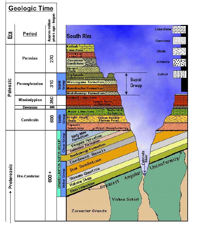
After this introduction to stratigraphic nomenclature, we now take a look at the geologic column for the Grand Canyon, and some examples of how the nomenclature is applied. Then in the following section, we will consider the extension of these concepts to the moons and planets.
Figure 3 shows a conceptual cut through the Grand Canyon alongside a geologic column. Of the many remarkable aspects of the Canyon is that it's most recent layers belong to the Paleozoic epoch, and are already some 250 million years old. (Times on this and the previous figure were taken from different references, and agree only approximately.)
Several hundred million years of the Earth's history have been eroded and washed away from the Colorado Plateau in the region of the Canyon! A close look at some of the layers within the Paleozoic show that this has happened before. No layers represent the Ordovician or Silurian periods. Roughly a hundred million years is missing between the Temple Bute formation and the Muav Limestone. This missing time is referred to as an "unconformity." A more obvious example of this phenomenon is the great uncomformity,where the Tapeats sandstone sits atop and truncates the tilted members of the Grand Canyon Supergroup. Presumably, additional material belonging to these tilted layers once existed. However, when the region was uplifted, the missing regions would have been higher than those which remain in the Supergroup. Erosion and weathering removed them, and the Tapeats Sandstone was eventually deposited on top of what remained.
The oldest rocks through which the river cuts extend into the Pre-Cambrian, though not as far as the Archean eon.
The decision to refer to a layer of similar rocky or sedimentary materials as a group rather than a formation is somewhat arbitrary. We shall use the top layers of the Canyon as an illustration of the concepts of groups and formations. The layers we consider begin and end in Permian period, the youngest division of the Paleozoic.
The uppermost layer of the Canyon is called the Kaibab Limestone. It is followed by the Toroweap formation, the Coconino Sandstone, and the Hermit Shale. The first set of layers considered part of a group are members of the Supai. Divisions of the Supai Group have the tongue-twisting names of Esplanade, Wescogame, Manakacha, and Watahomigi. The latter three are classified as formations, while the Esplanade is actually considered a ``subgroup.''
Figure 3: Geologic Column for the Grand Canyon
In late May of 2000, my sons, granddaughter, her Mom, and I hiked for about a mile down the Bright Angel Trail of the south rim of the Canyon.
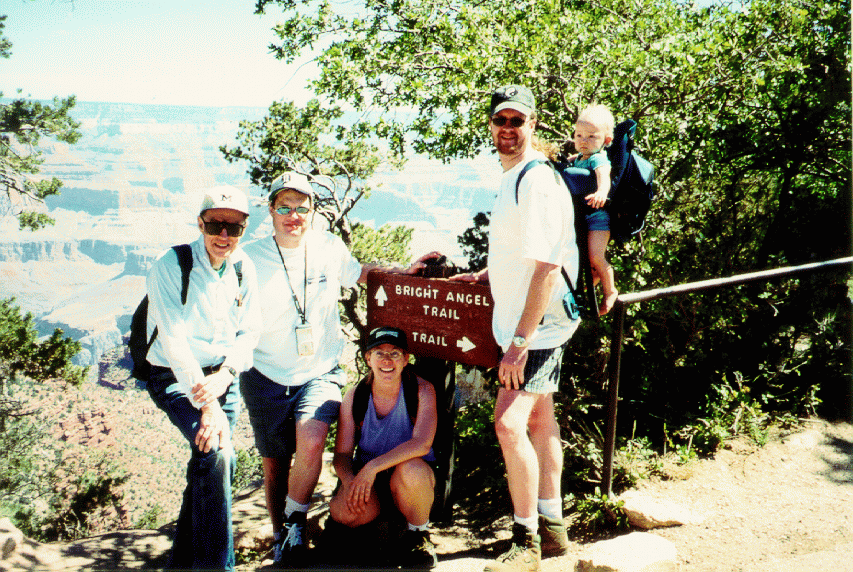
The idea was to get some images of the named layers from a distance that would be close enough so they could be seen distinctly, but not so close that the divisions would appear merged. I also had a guide to the trail, so it was possible to identify the layers unambiguously. Figure 4 shows the the top layers, and it is easy to see the divisions between them.
Figure 4: Top Layers of the Grand Canyon. The image was taken near the beginning of the Bright Angel Trail.
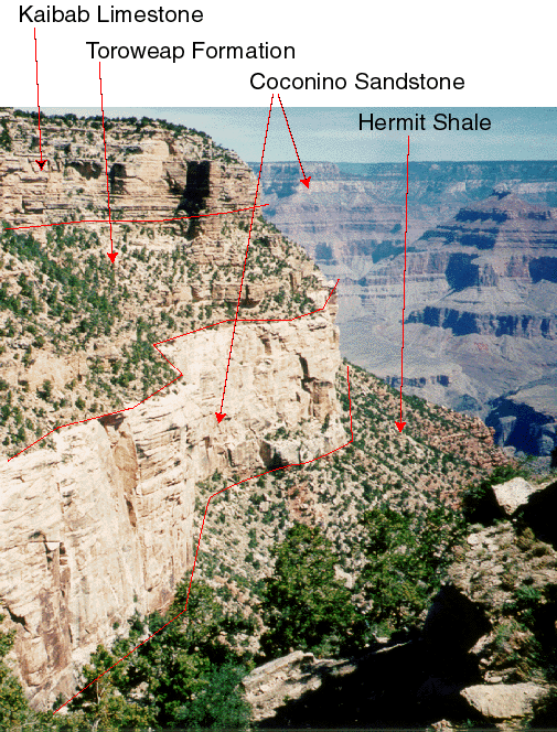
Subtle information is contained in the names of the layers. The top 4 qualify as formations, yet the Kaibab is called the Kaibab Limestone, the Coconino the Coconino Sandstone, but the Toroweap is called the Toroweap Formation. This is because the first two formations are mostly either limestone (Kaibab) or sandstone (Coconino), but the Toroweap formation consists of both limestone and sandstone.
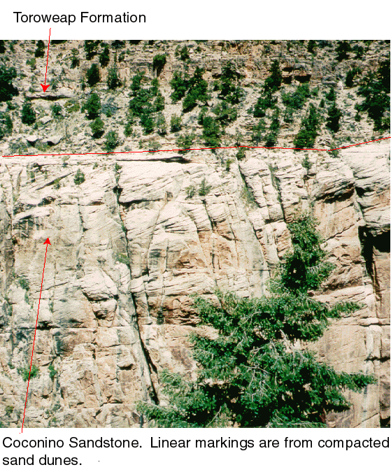
The Coconino Sandstone is a distinctive layer, readily seen on the distant rim of Figure 4---so long as one knows what to look for. One can see lineations from compressed sand dunes in the closeup in Figure 5, where the transition from the Toroweap formation is even more obvious than in the previous figure.
Figure 5: The Coconino Sandstone
Vertical cuts by a river or a roadbed are easy to associate with steps (backward) in time. But circumstances in the history of planetary bodies conspire in such a way that steps along the surface can also be steps in time. This is readily illustrated in north-central Arizona. As our family drove westward toward the Grand Canyon, we soon passed through areas where the surface rocks were only about a million years old. This fact may be seen from color changes on a geological map.
Figure 6 is a simplified example of a
geological map of a region of northern Arizona showing the Grand
Canyon and nearby Flagstaff on US 40. The colors show the ages of
the surface rocks. The Permian Kaibab limestones are marked P,
including most of the region surrounding the Grand Canyon. However, there
are much younger Tertiary volcanics (Tv) nearby as well as even
more recent Quaternary-Tertiary volcanics (QTv). A region in the western
part of the state is mapped as Mississippian (M), one of the periods
of the Paleozoic. This time corresponds to the layers of the Grand
Canyon belonging to the Redwall Limestone and Temple Bute formations,
but our map does not show these details. We do indicate, with
olive-green, parts of the Canyon where the
Colorado River cuts through Pre-Cambrian rocks
(![]() ).
).
It is common for the symbols of a geological map to indicate the nature of the materials as well as their age. Thus `Tv' indicates not only the age, but also the origin of the rocks--volcanic. Lunar and planetary maps follow this convention. For example, heavily cratered plains belonging to the Copernican system of the Moon, might be marked Cc.
Figure 6: Schematic Geological Map. The region shown is in the region of the Grand Canyon.

It is also common for the symbols associated with color (or shading on a grayscale map) to indicate appropriate systems groups or formations. We will see examples on the lunar map below.
We could continue to discuss the fascinating features of the Grand Canyon and its surroundings, but our purpose is to use them as an illustration of concepts that are of value in describing the surfaces of extraterrestrial bodies, and their histories. In the next sections, we begin our discussion of the lunar surface, and give a short introduction to its geological mapping.
In the following sections, we will be referring to a few of the specific craters and maria that appear on the nearside of the Moon. We need to know some of these names for the discussion to make sense. Therefore, we present a lunar image, with some of the more important features labeled.
Figure 7: Some Features on the Nearside of the Moon- (Lick composite photo, annotated by the author).
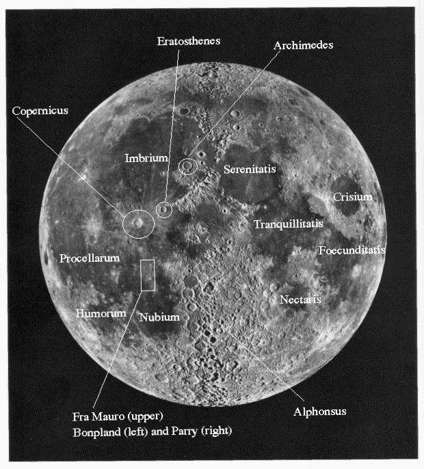
The smooth, dark features are the maria or lunar seas. They are quite dry now, but they were once liquid rock, lava, which flowed out smoothly, covering wide areas of the Moon. Of the 9 maria labeled, 8 actually have "mare" (singular of maria) incorporated in their names. Thus, the full names are Mare Imbrium, Mare Serenitatis, Mare Tranquillitatis, etc. Procellarum is known as Oceanus Procellarum. The maria are generally thought to have been formed as a result of a single major impact event, which left a more or less circular feature. Of the nearside maria, Imbrium is the best defined, and it is not surprising that the lunar geological history is most easily followed by examining features near it. No obvious center exists for Procellarum. Perhaps that is why it has a unique name.
If we omit Mare Crisium, the remaining 8 maria may be recalled using the mnemonic: I'm Sure that Frogs Never Need Hair Pieces. This gives us the first letter of Imbrium, Serenitatis, Foecundatatis, Nectaris, Nubium, Humorum, and Procellarum. The mnemonic is from a student in an introductory astronomy course at the University of Michigan.
One can understand most of the history of the moon and its current form with the help of these 9 maria and the 5 (or 7) craters named in the above figure. Even the unaided eye can pick out the larger maria, and with a small telescope for example, one can see the major craters. Since one can see these features in the sky for oneself, it's worth knowing their names. The Moon is the only extraterrestrial object for which this is so.
Eugene Shoemaker was not the first to apply geological mapping techniques to the lunar surface, but he was one of the pioneers, and arguably the most important of them. An illustration of just how ripe this field was for the plucking may be seen in Shoemaker's 1962 study of the region surrounding the Copernicus crater. It is based on a photographic copy of an image taken in 1929 by the astronomer Francis Pease. Schoemaker purchased his copy at the Cal Tech bookstore! It's pretty rare that ground-breaking research can be done with materials that cost about the same as a fast food lunch, but the fruit was ripe, and Schoemaker was there to pluck it.
With the help of his bookstore photograph, Shoemaker divided lunar surface materials into five systems. Four of these are still in use. From the oldest to the youngest, they are the Pre-Imbrian, the Imbrian, the Eratosthenean, and the Copernican. The basis for this division is readily seen in the region of the Moon in the eastern and southern part of Mare Imbrium, and just south of the outer Imbrian ring, where the craters Copernicus and Eratosthenes are found. Shoemaker noted that rayed craters like Copernicus and their ejecta overlayed and sometimes destroyed parts of craters with bright rays. Thus rays could be taken as an indication of relative youth, and indeed, the brighter the rays, the younger the craters. This relation seems to hold not only on the Moon, but on the surfaces of Mercury, Mars, and other satellites.
It is a little easier to illustrate the geological mapping of the Moon with the help of Figures 7 and 8 (below) than with Shoemaker's image from the Cal Tech bookstore. First, we give ages to the named systems as they are presented today. This is shown in Table 2.
| System | Approximate Starting time (years ago) |
|---|---|
| Pre-Nectarian | 4.6 x 10⁹ |
| Nectarian | 3.92 x 10⁹ | Imbrian | 3.85 x 10⁹ |
| Eratosthenian | 3.2 x 10⁹ | Copernican | 1.2 x 10⁹ |
Shoemaker associated his systems with the equivalent of geological time units which he called periods. This distinction is for the experts, and we shall discuss the lunar systems as though the words meant the same as lunar periods.
We have already noted that the lunar systems correspond to time intervals of one or more billions of years, far far more than terrestrial systems. The rock-stratigraphic term that corresponds to billion-year intervals on the Earth is the eonothem. But it seems that term is used primarily to fill a space in a table such as our Table 1. Planetary geologists have simply retained the "system" as the chrono-stratigraphic unit corresponding to the widest time interval. This is true not only for the Moon, but also for Mars, and other planetary and satellite surfaces that have been mapped.
It is common to group the Pre-Nectarian and Nectarian systems into the Pre-Imbrian, as in Shoemaker's original paper. We use this simplification below. The duration of the Nectarian is relatively small. If the time intervals given here are correct, the Nectarian lasted 3.92 - 3.85 = 0.08 billion years, or 80 million years. This is short relative to the other lunar systems. Nevertheless, recent books and articles on the Moon include the Nectarian System, so we include it here.
The isolated maria--unlike Procellarum--are thought to have originated with a single meteoroid impact which left a series of concentric mountain rings. Basalt flooding and additional smaller impacts obliterated the inner rings. The regions are now called basins. In the case of Imbrium, we can see only a part of the outer ring, that is most well formed to the southeast. Nectaris though rounded, has no such notable ring fragment, and the conclusion that it is older is easy to understand.
Shoemaker originally identified a ``Procellarum system.'' Regions belonging to it were smooth with relatively sparse cratering, materials which we now identify with lava flows that occurred some hundreds of millions of years after the impact that created the Imbrian basin. Since Oceanus Procellarum consists largely of such material, the basis for the category is obvious. Later mappers ``demoted'' these materials from the chrono-stratigraphic category (system) to the rock-stratigraphic category of the Procellarum Group, because it was not easy to place them securely in the Moon's history. Indeed, a close examination of mare reveals a boundaries where one lava flow overlapped another, clearly showing the ages of the surfaces differ. However, the amounts of time between the floods are not easily determined. Eventually, Don Wilhelms, who made extensive maps of the Moon in the post-Apollo era, recommended that Procellarum Group be replaced by the term mare material. We shall follow that recommendation below.
In this section we will explore some simplified methods of determining the relative ages of regions of the lunar surface. They are not intended to make the reader a professional, but they should provide a basis for understanding the fascinating endeavor of reading the history of the Moon by looking closely at its features. For simplicity, we include Nectarian materials within the Pre-Imbrian.
We turn first to the time- and chrono-stratigraphic units. Here are some general principles:
We are now in a position to look at images of the Moon and read some of its history. The widest divisions may be seen with the naked eye: the dark maria and bright highlands. These are the features that make the so-called "man in the Moon." It is hard to pin down what people mean by this phrase, but surely the notion arises from the blend of light and dark areas--the highlands and the maria.
Highlands, especially in the south-central regions of the nearside are pre-Imbrian. Toward the highlands near the center of the disk, thick ejecta from the Imbrian event cover the highland rocks. Regions near the crater Alphonsus (Figure 7) are now mapped into the lower (or older) Imbrian system.
The dark maria may safely be classified as Imbrian. The rocks returned by the Apollo astronauts showed clearly that this material is basaltic, and similar in nature to the fluid lavas that flowed over large areas of northern Idaho and western Washington state, near the Columbia river. These lavas are referred to as ``volcanic'' in origin, even though they are not associated with large volcanoes. Some time after the basins were originally excavated, they were flooded. It is easy to see that this must have been the case, as a few craters within the basins have smooth floors. A prime example is Archimedes, which we discuss below.
Telescopic aid is required to see the rough-floored Eratosthenes, just at the southern edge of the Appenine mountains (see Fig. 8), that form the southern border of the Imbrian basin, and a little further south, we see the bright-rayed crater Copernicus. These features may all be seen with a small telescope or a good pair of binoculars.
Figure 8 shows two juxtaposed photographs taken at the Lick Observatory near the beginning of the 20th century. On the right is an approximate geological map of the region. It follows more detailed maps made by experts (cf. the article by Paul Spudis in The New Solar System, Sky Publishing Corp. 1999, cf. p. 128). On the photographic images, one can easily see the basalt-filled floor of Archimedes. It is mapped in blue. Larger regions are labeled `Im' for Imbrium, mare-materials. Recall that `mare-materials' were once called `Procellarum group.'
Extensive regions, mapped in brown, are mapped into the Imbrian System. The Appenines Mountains (Iam) form the south eastern rim of Imbrium. Additional regions in the southeast corner of our map belong to the Imbrian. A small area, between the crater Archimedes and the Appenine Mountains proper has been mapped as the Appenine Bench Formation (Iap). The chemistry of materials in this region is unusual. The Lunar Prospector detected the most intense emission from the radioactive element thorium near here. This emission may come from a hypothetical layer of the Moon's subsurface regions that was particularly rich in elements whose ions do not fit easily into the crystal structures of common lunar minerals. This is a fascinating topic, but we cannot pursue it here (cf. http://lunar.arc.nasa.gov/).
The Eratosthenean System (green) is represented on our map only by the crater Eratostheses itself, and one small crater south of Copernicus. The label `Ec' stands for `Eratosthenean, cratered.'
The Copernican system is represented by the crater Copernicus, and Kepler to the west. The rays of Copernicus are not outstanding in Figure 8 because of the sun angle, but the rays can be seen well into the Imbrian Basin, as we have attempted to indicate with the gray lineations. Kepler's rays are brighter, both because of the slightly different sun angle, but also because the crater is younger.
Note that both Copernicus and Eratosthenes have rough floors. This means that unlike Archimedes, they were formed after the basalt flooding. Eratosthenes has no rays, and therefore it is older than Copernicus. Two smaller craters to the north and east of Archimedes are also mapped into the Copernican (gray). Because of the sun angle, one can not see their rough floors, but other images, clearly show they are not flooded. The upper, larger of the two has a central peak, characteristic of craters in its size range.
Figure 8: Geological Map near the Southeast portion of Mare Imbrium.
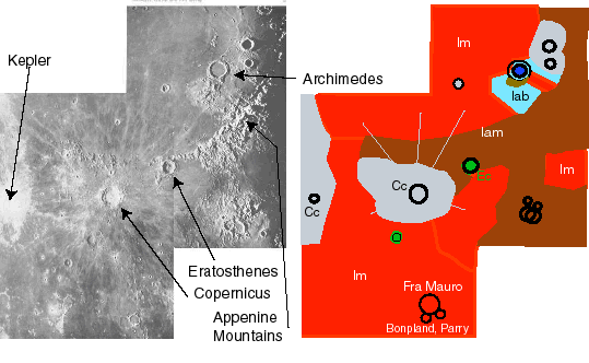
A small area near Archimedes is mapped as the Appenine Bench Formation. It belongs to the Imbrian System, and is therefore designated `Iab.' Materials of this region have a distinct chemistry that is shown by the Apollo 15 samples, as well as from recent remote sensing from orbit. Rocks in this area may be distinctly rich in elements whose ions do not fit easily into the crystal structure of the common moon rocks. Among these elements are radioactive thorium and uranium, whose gamma-ray emissions were measured by the Lunar Prospector. This is a fascinating topic, but we can not pursue it here (cf. http://lunar.arc.nasa.gov/).
The layperson's literature on lunar exploration is liberally sprinkled with references to certain lunar groups and formations. While these words have common meanings, or perhaps because of these common meanings, one cannot fully appreciate this literature without some understanding of the terms as used by geologists. We have therefore been at some pains to illustrate these terms, with the help of the Grand Canyon.
Highly technical terms have a way of insinuating themselves into the popular literature and textbooks. They are often memorized and repeated by students and professors alike, who sound as though they understood them. We end our discussion of the Grand Canyon and the Moon with a summary of some of the lunar materials known by their rock-stratigraphic classifications, groups and formations.
Possibly the most widely discussed lunar formation was named after old crater Fra Mauro. With a little effort, Fra Mauro crater can be seen on both Figures 7 and 8. Figure 9 (left) is a NASA image from an Apollo orbiter showing Fra Mauro crater, along with Bonpland (southwest) and Parry (southeast). A boom of the spacecraft projects from the right; the arrow points to the location of the Apollo 14 landing site.
Figure 9: Fra Mauro Formation From Lunar Orbit- (NASA images).
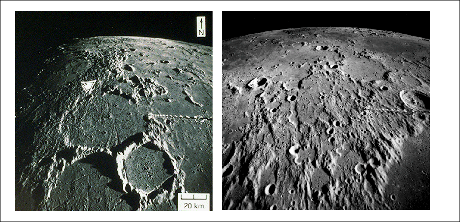
The site for the Apollo 14 landing was chosen so the astronauts could sample and return material from the Fra Mauro Formation. Because of the favorable sun angle, it is possible to see north-south lineations that have been determined to point to the center of the Imbrian Basin. These lineations are seen even more clearly in the image on the right, which is of a region in the central highlands. The fact that these lineations line up with the center of Imbrium led to the conclusion that the Fra Mauro formation consisted of material ejected in the Imbrian event.
The smooth-floored crater that is seen only partially, in the right-lower corner is Ptolemaus. It lies just north of Alphonsus, indicated in Figure 7.
Another well-known lunar formation is the Cayley. Lunar geologists seem to have a proclivity for choosing small craters to name things after. While Fra Mauro is 101 km across, Cayley is only 14, and you need a very good Moon map to find it (4oN, 14oE). This small crater just happens to be in the neighborhood where lava from Mare Tranquillitatis joins smooth plains to its west that seem to belong to the central highlands. This is shown on the left image of Figure 10. Cayley is the small crater appears in the upper left-central region at the intersection of the two arrows just outside the image.
Figure 10: Cayley Formation-(from Lick Photographs)

The upper arrow is near the division between the darker mare material (Procellarum Group) and lighter, but still relatively smooth regions. The boundary is easy to follow on the contrasty image. The smooth plains were designated Cayley Formation. At one time it was speculated that these materials might be basaltic in nature, and early discussions of lunar rocks mentioned "highland basalt." While the interpretation of some lunar samples is still open, it is now generally agreed that the Cayley Formation is primarily ejecta, emplaced, or sifted down from above.
Superficially, Cayley appears smooth, and a casual glance at a crater such as Alphonsus in Figure 10 (right) could lead one to believe its floor had been flooded with basalt just as Archimedes's had. Closer inspection shows underlying relief that has been covered by debris deposited from above. That is the Cayley Formation. Impact craters, perhaps mostly Imbrium itself, provided the sources of the debris.
We thus find that the Cayley and Fra Mauro Formations have much in common. But the distinct names are still useful. The materials are found in different regions of the Moon, and have different appearances. The Fra Mauro is characterized by streaks and linear features as though it consisted of material shot horizontally from the impact. Cayley material, for which there are few or no telltale streaks, must have been emplaced from more ballistic trajectories.
The Apollo 16 landing site was chosen to investigate regions near the 48-km wide crater Descartes that had been designated Descartes Formation. Once again, it was widely thought the material was basaltic in origin. However, rocks investigated in the neighborhood of the lander were highly brecciated and similar in composition to Cayley. While the origin of Descartes material is still not certain, much of it may also have originated in the Imbrian event. Perhaps an unusually dense cloud of dust deposited it is a few localized areas. The crater Descartes itself is filled with the material, to the point where much of the crater is hidden.
The notion of a geological groups or formations is not something the average person thinks about every day. But the concepts do appear in the popular literature, and one gains from having a sharper notion of what these terms mean. The following passage occurs in James Michener's historical novel Centenial, about a region in Colorado on the South Platt River:
`My good man,' Professor Wright said condescendingly as he kicked at the base rock. `This is Morrison. Do you understand that? Morrison!'
`Who's Morrison?' the reporter asked.
`It's a formation! ... It's a purplish formation of clay and rock. It exists in a small belt throughout the west, and where you find Morrison, you find dinosaurs.
A large number of geological maps now exist for the Moon, other satellites, and planets with solid surfaces. It is common for the geologists to give descriptive names to regions such as ``lineated basin material,'' or ``older plains material.'' It is likely that these areas will become named formations, like the Fra Mauro or Morrison when they have been the subject of intensive study. Certainly, this is the situation for distinctive terrestrial regions.
Evidence of life forms in the Hadean Eon have been reported to exist in the Isua rocks of Greenland. The Isua is a formation. We know from the life experiments of the Viking landers, that evidence for life on Mars will not be easily found. But it is possible that some day, Martian explorers may report that evidence of past life forms does exist in certain special rock formations. Should this happen, the names of these formations will become well known.