One of the most critical issues confronting the global society today is the understanding of the relationship that humans share with each other and with the environment. As we place greater demands on the environment, we also place increasing demands on the relationships among people. This is not a new issue. Throughout history, humanity has struggled with a fair and equitable distribution of resources and access to resources. More recently, a body of literature has been developing that convincingly documents the idea that the causes of environmental destruction and negative environmental impacts have their origins in social relations, specifically the dynamics of class and race (Bryant & Mohai; Painter & Durham, 1995). This understanding supports an argument that environmental degradation and social injustice go hand in hand (Faber, 1993).
Instead of the popular notions of global environmental collapse, it is more likely that there will be a slow unevenly distributed environmental deterioration that will be confounded by humanitys ability to adapt, deny and forget. While there will be growing pockets of wealth, environmental conservation and protection, there will be many other areas that experience desperate poverty, environmental contamination, and resource depletion. This is not just simply the familiar North versus South dynamic. Rather there are increasing pockets of the "North" in the South and the "South" in the North where disproportionate environmental dilemmas will play out (Athanasiou, 1996).
Moreover, during the past decade, issues of justice, equity, and racism have become significant developments in the environmental movement, particularly in regards to demographics and the environment. Researchers, scholars, professionals, community activists and members of the general public are beginning to see that environmental issues concern more than wilderness protection, pollution prevention and resource conservation. However, a number of important questions need to be explored further: In what ways do factors such as race and class interact in relation to environmental problems? How have attempts to solve environmental problems generated social problems? What is the link between environmental protection and social justice? How do specific environmental problems and hazards disproportionately affect certain communities over time? How have policy decisions and implementation addressed concerns about disproportionate exposure?
One response to this disparity has been the environmental justice movement that has sought to identify and challenge the disproportionate exposure that minorities or low-income populations have to negative environmental impacts, particularly the siting of hazardous waste facilities. The Region V office of the US EPA Superfund Division offers the following definition for environmental justice:
One of the first to raise questions about the connection between environmental hazards and social status in the U.S. was Alice Hamilton. Trained in medicine at the University of Michigan, Hamilton is known as the countrys first great urban/industrial environmentalist as well as a tenacious reformer, compassionate advocate and cautious careful researcher. Hamiltons investigation of a serious typhoid epidemic in Chicago at the turn of the century, revealed a direct relationship between sewage outflow and outbreaks of disease in poorer neighborhoods (Gottlieb, 1993).
In 1972, A. Myrick Freeman presented a paper for Resources for the Future that addressed the distribution of Environmental Quality. This was one of the earliest reports that was able to show a quantifiable correlation between hazardous air pollution exposure (suspended particulates and sulfation) and income level. In three areas of study (Kansas City, St. Louis, and Washington, D.C.) lower income groups were consistently exposed to higher levels of pollutants. In his summary, Freeman concluded that environmental quality is positively associated with wealth.
Following on Freemans work, Peter Asch and Joseph J. Seneca carried out a national study that examined the systematic relationship between exposure to air pollution and economic and social characteristics of the population. Their findings showed a stronger correlation between income groups and air pollution than between racial composition and air pollution (1978). This study raises an important methodical concern regarding the unit of analysis for such studies. Asch and Seneca chose census tracts as the unit of analysis for their research while others (as will be shown later) work with zip code level information. Regardless of the unit that is selected or method of data analysis, an important characteristic that drives all of these studies is the principal that environmental policies in the U.S. should provide uniform regulations and ambient standards independent of local conditions and costs (Gianessi, Peskin, and Wolff, 1979).
A major event that helped focus national attention on the question of race, income and environmental hazards occurred in 1982 when state officials decided to locate a poly-chlorinated biphenyl (PCB) landfill near a predominately African American community in Warren County, North Carolina. This led to protests similar to the civil rights movement of the 1960s and inspired further investigation into the link between social indicators and environmental hazards (Mohai and Bryant, 1992).
In 1983 the General Accounting Office (GAO) conducted an analysis of the socioeconomic and racial composition of the communities surrounding the four major hazardous waste landfills in the South. The GAO study found that 3 of the 4 landfills were located in communities that were predominantly black and living below the poverty line.
The GAO report prompted the United Church of Christs Commission for Racial Justice to conduct a nation wide study (using zip code data) of the distribution of hazardous waste sites to determine if there might be results similar to the GAO report. The Commission found a clear pattern. The study revealed that the proportion of minorities residing in communities that have a commercial hazardous waste facility is about double the proportion of minorities in communities without such a facility. Where two or more facilities are located, the proportion of resident who are minorities is more than triple. Furthermore, the study showed that race is the single best predictor of where commercial hazardous waste facilities are located (United Church of Christ, 1987).
In an analysis of 16 studies which explore this phenomenon, including their own in the Detroit area, Paul Mohai and Bunyan Bryant determined that regardless of the scope of the study, the distribution of pollution has been found to be inequitable by income. Where the distribution of pollution has been analyzed by both income and race, in most cases race has been found to be more strongly related to the incidence of pollution than income (Mohai and Bryant, 1992).
The Data
This study uses data that has been compiled by Dr. Elaine Hockman of the Research Support Laboratory at Wayne State University. Dr. Hockman has gathered information on 907 variables including race, income, environmental hazards and public health for all 873 zip codes in the State of Michigan. Sources for the data include the Michigan Department of Environmental Quality (DEQ), the Michigan Department of Public Health (DPH), US EPA, the 1990 Census, and several others. I will be using eight of the variables to explore the spatial association between race, income and environmental hazards. Six of the variables represent various environmental hazards by zip code and the other two variables provide information on median household income and the ratio of minorities to whites for each zip code.
For this report I am simply looking at the spatial association of race, income and selected environmental hazards. An analysis of the statistical correlation of these variables will be done at a later date. A detailed explanation of each variable that I will be using is given below:
Median Household Income Quartiles (QHHINCOM): This categorizes 1990 Census information household income data in quartiles. Zip codes are classified as "1" (where the median household income is below $21,391 per year), "2" ($21,392-$26,999), "3" ($27,000-$35,042) and "4" (greater than $35,043). Therefore "1s" identify the poorer areas of the state and "4s" identify the wealthier areas.
Ratio of Minorities to Whites (QMIN2WHT): This variable also relies on 1990 Census information and categorizes zip codes based on the ratio of minorities (all minority groups) to whites. This is the total population for a zip code minus the white population divided by the total population. Zip codes identified with a "1" are areas with no minorities and areas identified by a "4" represent those zip codes with the most minorities. Zip codes with a "2" or "3" represent the quartiles between "1" and "4".
Toxic Release Inventory 1989 (TRI.N89): In 1988, the US EPA began collecting information releases, transfers, and others waste management practices for certain listed toxic chemicals. The current Toxic Release Inventory (TRI) reporting requirements apply to facilities in the manufacturing sector of the economy with ten or more full-time employees, and that exceed an activity-based threshold limit for one or more for the 650 toxic chemicals and chemical categories on the TRI list. This information is collected annually by EPA. For this data set, this variable represents the total number of chemical records (or number of TRI chemicals) for a particular zip code. It does not quantify the amounts of various TRI chemicals for each zip code.
Leaking Underground Storage Tanks (LUST.N): This variable quantifies
the number of Leaking Underground Storage Tanks (LUST) sites identified
in Michigan in 1990. Examples of LUST sites are leaking fuel tanks at service
stations, deteriorated or abandoned home heating fuel tanks, etc. As with
the TRI variable, the LUST variable only quantifies sites, it does not
rate the severity of contamination, at a particular site.
Number of Incinerator Emissions (INCIN.N): This data represents
the total number of incinerator records for a particular zip code. Like
the TRI 1989 variable, the incinerator variable counts the number of types
of emissions such as carbon dioxide.
Number of Hazardous Waste Management Facility Sites (HAZFAC.N):
This is the total number of hazardous waste facilities located in each
zip code.
Number of Landfills (D.NDUMP): The number of landfills located
in each zip code.
Number of Chemicals at Act 307 Sites in 1990 (ACT.90NC): Act
307 is the Michigan Environmental Response Act of 1982. It provides for
the identification, risk assessment, and priority evaluation of environmental
contamination at certain sites in the state. This variable represents the
total number of chemicals identified under Act 307 in a particular zip
code in 1990.
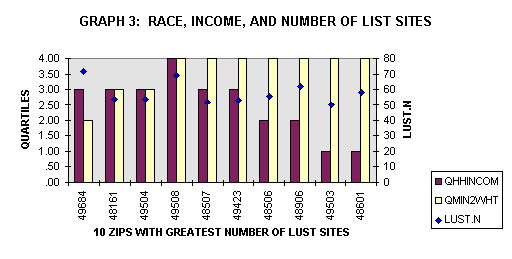
Working with these variables, I have used Excel to sort out the top (or worst) ten (there was often a natural break here) zip codes for each of the six environmental hazard variables (1989 TRI, LUST sites, number of incinerator emissions, number of hazard waste facilities, number of landfills and number of Act 307 chemicals). The relationship of these top ten zip codes is then graphed to compare the race and income information for that zip code with one of the environmental hazard variables. I then display GIS images created in Arcview to show the spatial association of these data sets.
While the data cover zip codes for the entire state, the maps that I have created only reflect the Lower Peninsula of Michigan as the interactions between the variables I have selected only occurs in this portion of the state.
Analysis
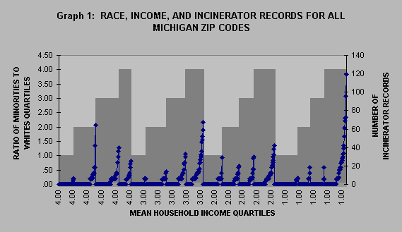
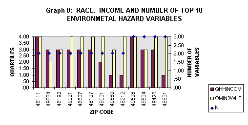
Graph 1 bears some resemblance to a standard demographic transition map. There are periods of low growth, periodic peaks and valleys and finally exponential growth resulting in a steep climb. While this graph does not represent population figures it does represent one of the most disturbing facts of the population-environment dynamic: the disproportionate exposure to environmental hazards that certain groups experience because of their social class or their race. In the dark gray bars, graph 1 displays mean household income values (QHHINCOM) in descending order on the x-axis, the ratio minorities to whites (QMIN2WHT) in ascending order on the y1-axis. The blue line represents the number of incinerator records (INCIN.N) on the y2-axis. All of the data are based on zip code level information. The graph dramatically displays the relationship between race, income and incinerator records. The exponential rise in the number of incinerator records on the right hand side of the graph is associated exclusively with zip codes that represent low-income area and areas with high minority populations.
1989 TRI (TRI.N89)
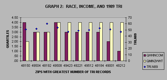
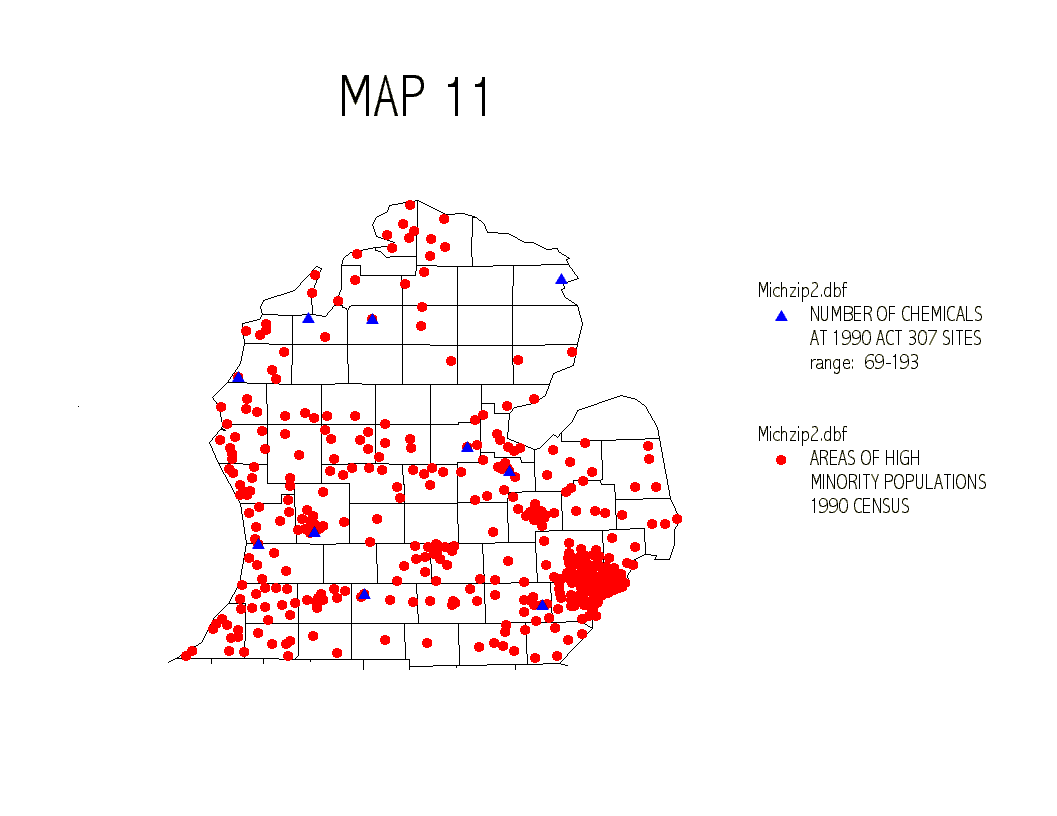
This graph shows that for the 10 zip codes with the highest number of TRI records in 1989 were also zip codes with primarily minority populations. Only one zip code had a QMIN2WHIT value of 2. On the other hand there is a wider range of representation in the QHHINCOM values. While there is a clear link between the zip codes of high TRI records and minority populations, there is not a clear link between zip codes of high TRI records and poorer areas. In fact many of the zip codes (8 out of 10) fall into the higher quartiles for household income. The GIS images display a clear connection between
QMIN2WHT and TRI.N89 (map 1) while the connection between QHHINCOM and
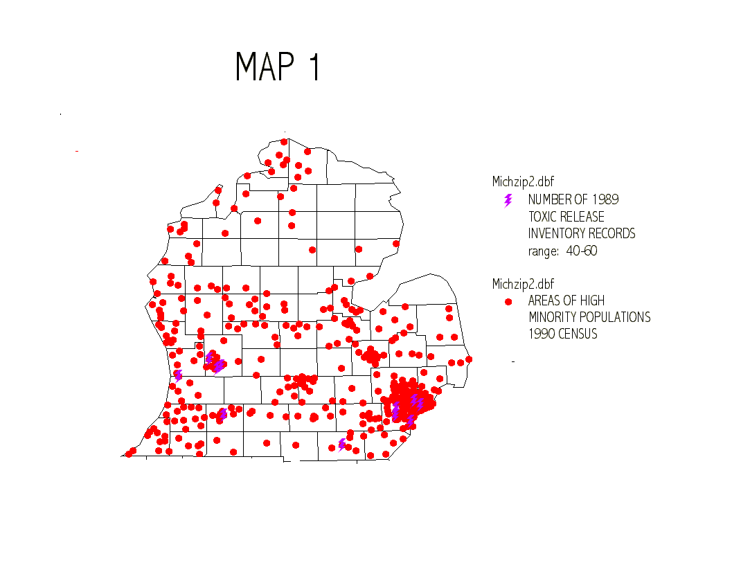
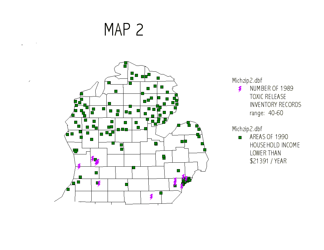
TRI.N89 (map 2 is not as direct).
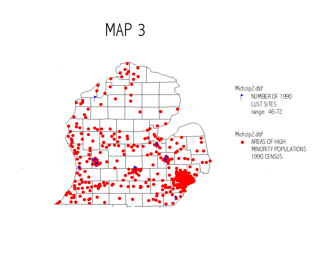
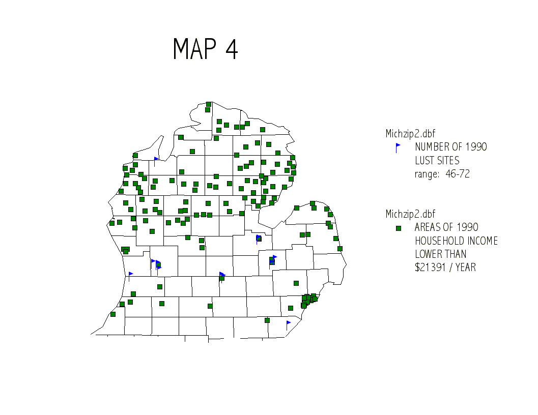
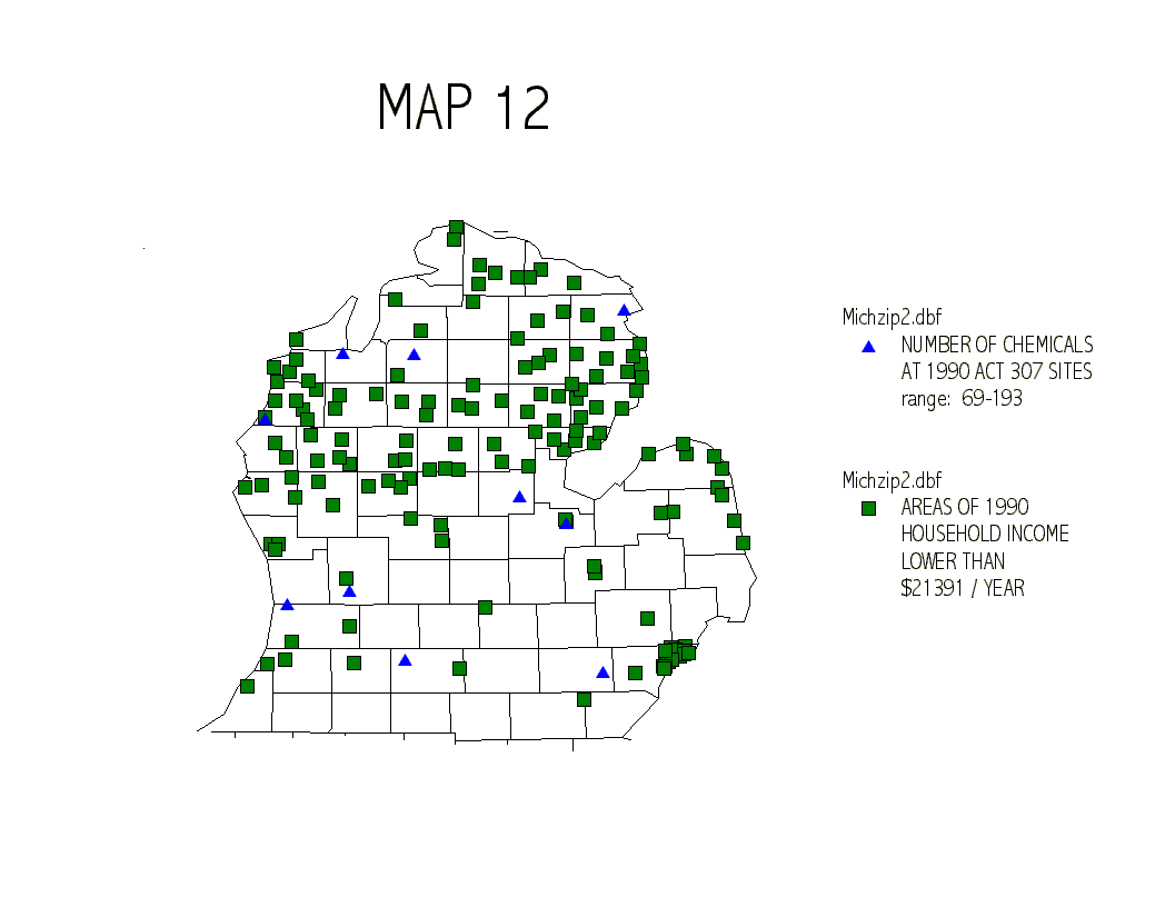
LUST Sites (LUST.N)
As with TRI.N89, there is a strong connection between QMIN2WHT and
the location of the zip codes with the highest number of LUST sites (map
3) and unclear connection between LUST sites and QHHINCOM (map 4).
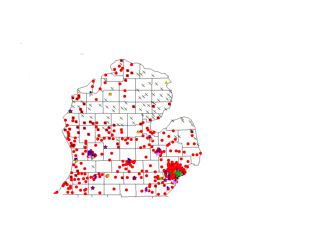
Incinerator Emissions (INCIN.N)
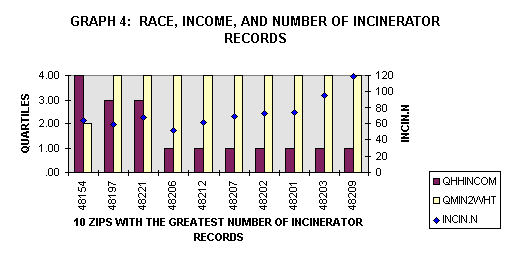
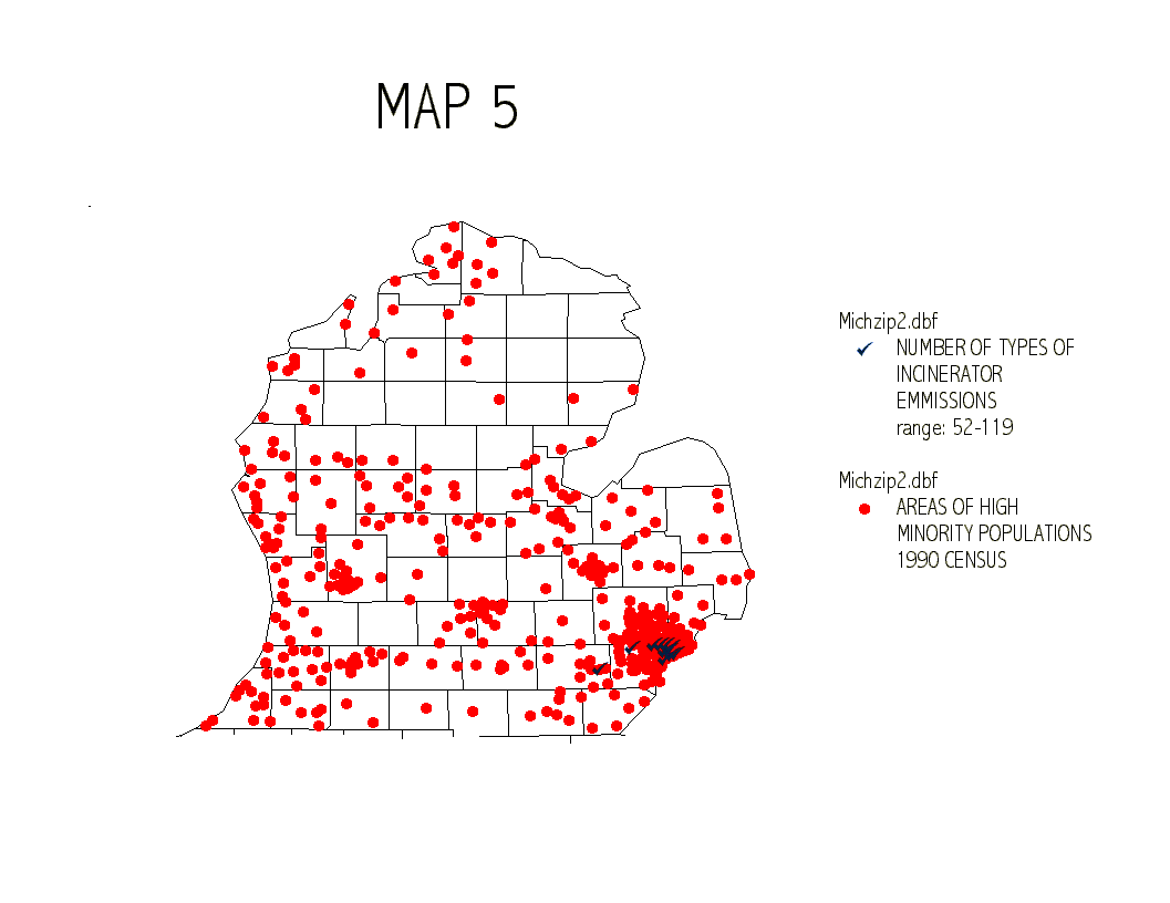
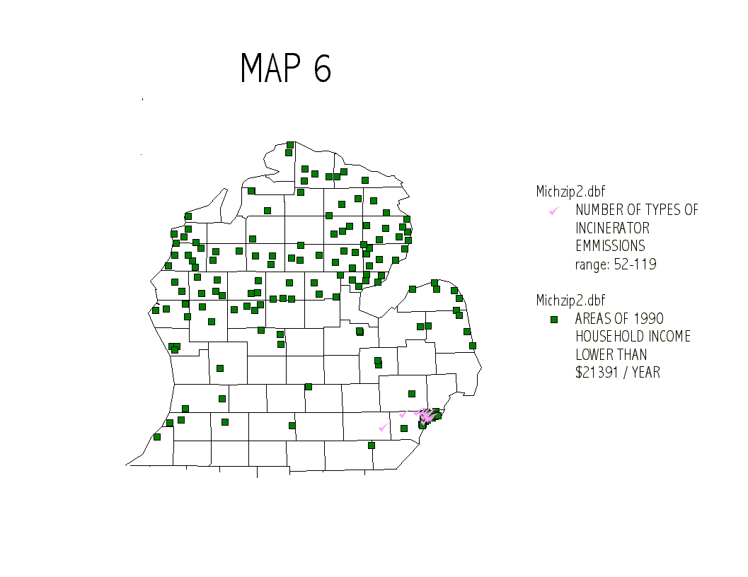
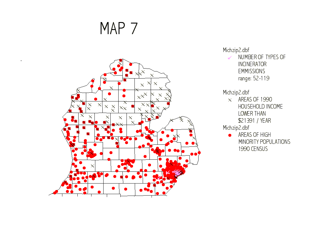
More than any of the other comparisons, the zips codes with the greatest
number of incinerator records (INCIN.N) show a close connection between
areas of low income and areas with the high minority populations. Seven
of the ten zip code areas have QHHINCOM values of 1 and QMIN2WHT values
of 4. A clear relationship between race, income and exposure to pollutants.
Map 7 below displays the combination of both data sets.
The graphs and maps that follow provide similar comparisons for HAZFAC.N, D.NDUMP, and ACT90.NC
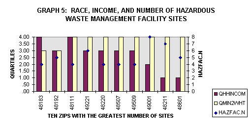
Hazardous Waste Management Facilities (HAZFAC.N)

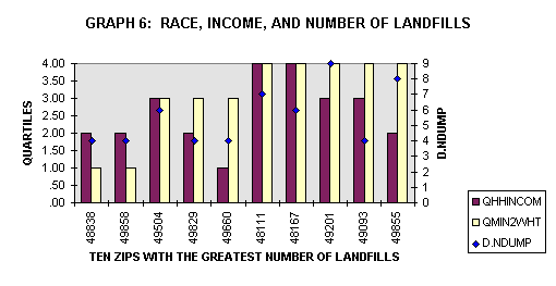
Landfills (D.NDUMP)

Act 307 Chemicals (ACT90.NC)
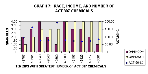
Reviewing all six of the environmental hazard variables reveals that,
in general, there is a strong association between the location of the ten
worst zips codes and zip copes with high zip codes having high minority
populations. Only zip codes that reflected high numbers of incinerator
emissions corresponded with both low income and minority populations. This
pattern is similar to the findings of Mohai and Bryant (1992) who concluded
that when the distribution of environmental hazards is analyzed by both
income and race, in most cases race is more strongly related to the incidence
of environmental hazards than income.
Questions
Even with these results, there still remain many questions and policy concerns. Given the strong relationship between environmental hazards and areas of high minority populations, is there a justifiable claim of environmental racism? Some claim that environmental racism probably does not apply as many of the communities reflected in the data only became minority communities after the area was industrialized or the polluting facilities had been sited, (Been, 1994; Been and Gupta, 1997).
These claims against environmental racism, however, do not sufficiently incorporate broader societal dynamics that force or encourage minority populations into undesirable or polluted areas. Why is it that many of the zip codes with the highest rates of environmental hazards are not only associated with high minority populations, but also with medium to high levels of income? If racism were not a factor in these areas, why would not wealthier minorities simply move out of the contaminated areas? Putting this debate aside, there still is a valid complaint that as present conditions stand, minorities bear a disproportionate burden in regards to environmental hazards.
Further Analysis
More work is clearly needed to explain and prove the association between environmental hazards, race, and income. This study has only looked at a simple graphical and spatial association of the variables. To strengthen the findings of this study, statistical analysis of the data needs to be done along with a comparative study using a different unit of analysis such as census tracts or a geographical region (one mile radius, 3 mile radius) around an environmentally hazardous site.
The data for this study has been limited to zip codes, as that was the basic unit for most of the combined data. The limitations of such a unit is that it is large and may not appropriately represent a particular area or community. For example the QHHINCOM variable (median household income) could be skewed by a combination of low and high-income households in one zip code. Another limitation of the data that I have used is that it does not address the severity of a particular hazard. For example, the D.NDUMP variable only counts the number of landfills per zip code. It does not account for the size or condition of the landfill. Despite the limitation of this study, some important policy considerations can still be suggested.
Policy
As a result of the growing awareness and interest in environmental justice, President Clinton issued Executive Order 12898 on February 11, 1994, to establish environmental justice as a national priority. This was the first presidential effort to direct all federal agencies with a public health or environmental mission to make environmental justice an integral part of their policies and activities. The Order, entitled "Federal Actions to Address Environmental Justice in Minority Populations and Low-income Populations," focuses federal attention on the environmental and human health conditions of minority populations and low-income populations with the goal of achieving environmental protections for all communities (U.S. Environmental Protection Agency, 1995). The result has been the establishment of several U.S. Environmental Protection Agency environmental justice programs across the country and many community groups that have begun to use the idea of environmental justice to challenge local environmental threats.
Furthermore, numerous environmental justice bills have also been introduced in Congress and various state legislatures have attempted to create a statutory basis for environmental justice claims. To date, though, none have been enacted. Essentially all of the legal or policy developments to date in the environmental justice field have concerned procedures, disclosure and general policies (Gerrard and Bose, 1997). A recent ruling in Flint, Michigan, however, may have significant implications for future environmental justice policy and legislation.
In October of 1995, the Flint chapter of the National Association for the Advancement of Colored People (NAACP), and several Genesee Township residents sued Governor Engler, the Michigan Department of Natural Resources and Genesee Township (collectively, the state) alleging that the state violated Michigans Elliott-Larsen civil Rights Act by authorizing the siting of a wood waste incinerator in a predominantly African-American neighborhood in Genesee County without considering the incinerators impact on a community that is "forced to bear a disproportionate burden of exposure to environmental harm." African Americans comprise only 13.9 percent of the population of the State of Michigan, and 19.6 percent of Genesee County, but they are a majority of the residents within a three-mile radius of the proposed plant. In addition, the NAACP claimed that the incinerator siting violated the Michigan Constitution and the former Michigan Environmental Protection Act. The state requested that the case be dismissed because the NAACP could not prove that the alleged discrimination was intentional. The court held that the NAACP was not required to demonstrate that the discrimination was intentional, only that it occurred, and allowed the case to proceed, (Smith, 1996).
Judge Archie L. Hayman of the Circuit Court for Genesee County presided over the case. While noting people of color bear a disproportionate and unfair burden of societys pollution he rejected the plaintiffs claim that the case constituted a civil rights violation, because "most, if not all, of the major polluters in Genesee County and especially in Flint were located prior to any significant African American population being located there," and there was no evidence that the states policy of not considering race in its permit review process had caused the disparate impact.
This was not the end of the case, however. Judge Hayman focused on a provision of the Michigan Constitution, which provides for the public health and general welfare of the people of the State. Thus, under both the state constitution and the Michigan Clean Air Act, Judge Hayman found that the state must, before issuing permits for any major polluting facilities, prepare comprehensive risk assessments that take into consideration the cumulative effect of all existing conditions. While Judge Hayman rejected the plaintiffs disparate impact theory, he directly endorsed the examination of the cumulative effects of different kinds of chemical exposure on vulnerable populations. (Gerrard and Bose, 1997).
The impact of Judge Haymans decision is still be analyzed. It has caused a major upheaval in the Michigan Department of Environmental Quality (DEQ). DEQ is currently appealing the decision, which could affect more than 480 air emissions permits pending before the DEQ Air Quality Division (McBrien, 1997).
The issue of cumulative effect is pertinent to the findings of the data
review above. Not only were most of the zip codes that were experiencing
the burden of environmental hazards in zip codes reflecting minority communities,
but in several cases they were the same community. As the graph below shows,
nine of the zip codes show up on two of the top ten lists and four show
up on three of the top ten lists of environmental hazard variables. (See
appendix A for a complete listing of all six variables with the corresponding
zip code, race and income information.)
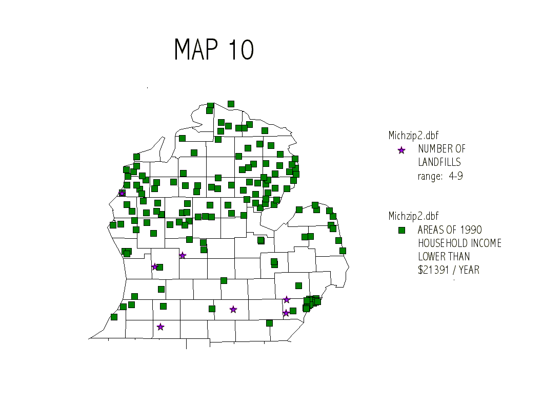
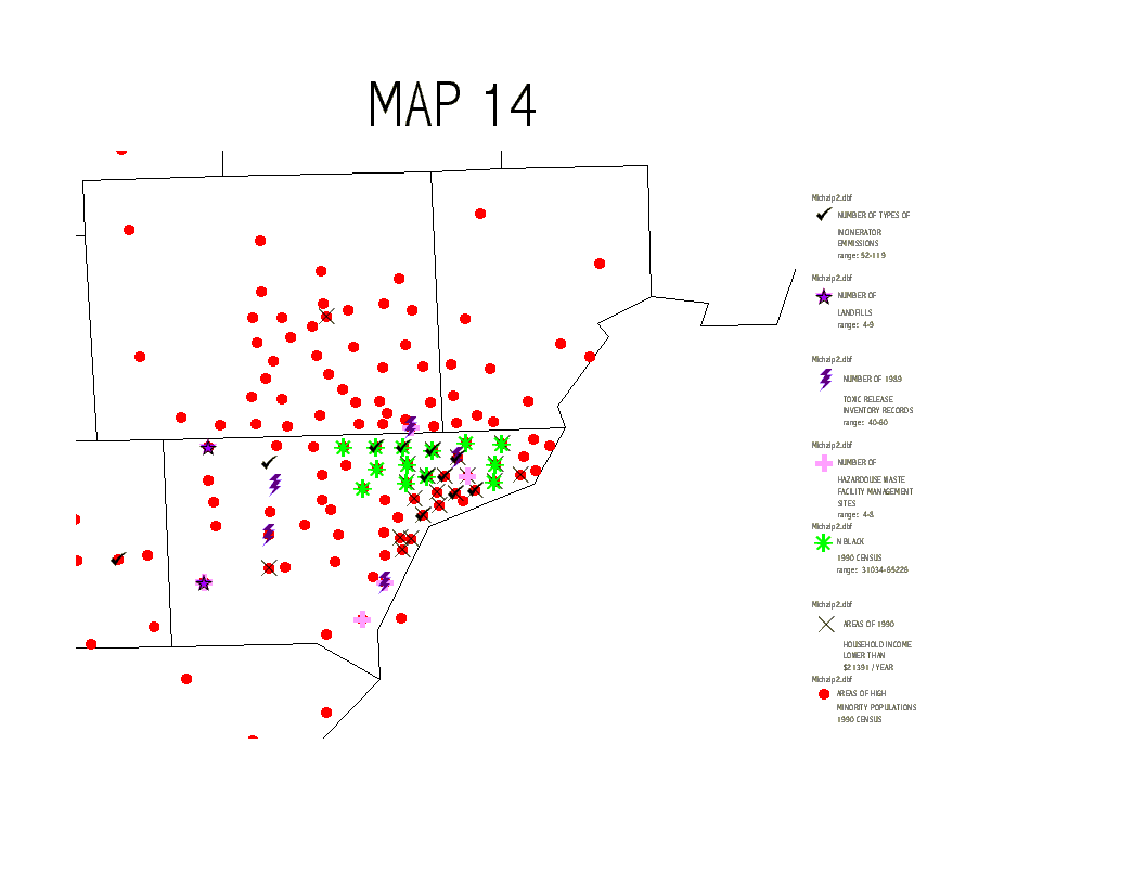
The cumulative impact of the data can also be clearly seen in the map
below, both for individual zip codes with multiple hazards and regional
cumulative impact from multiple hazards in the surrounding area.
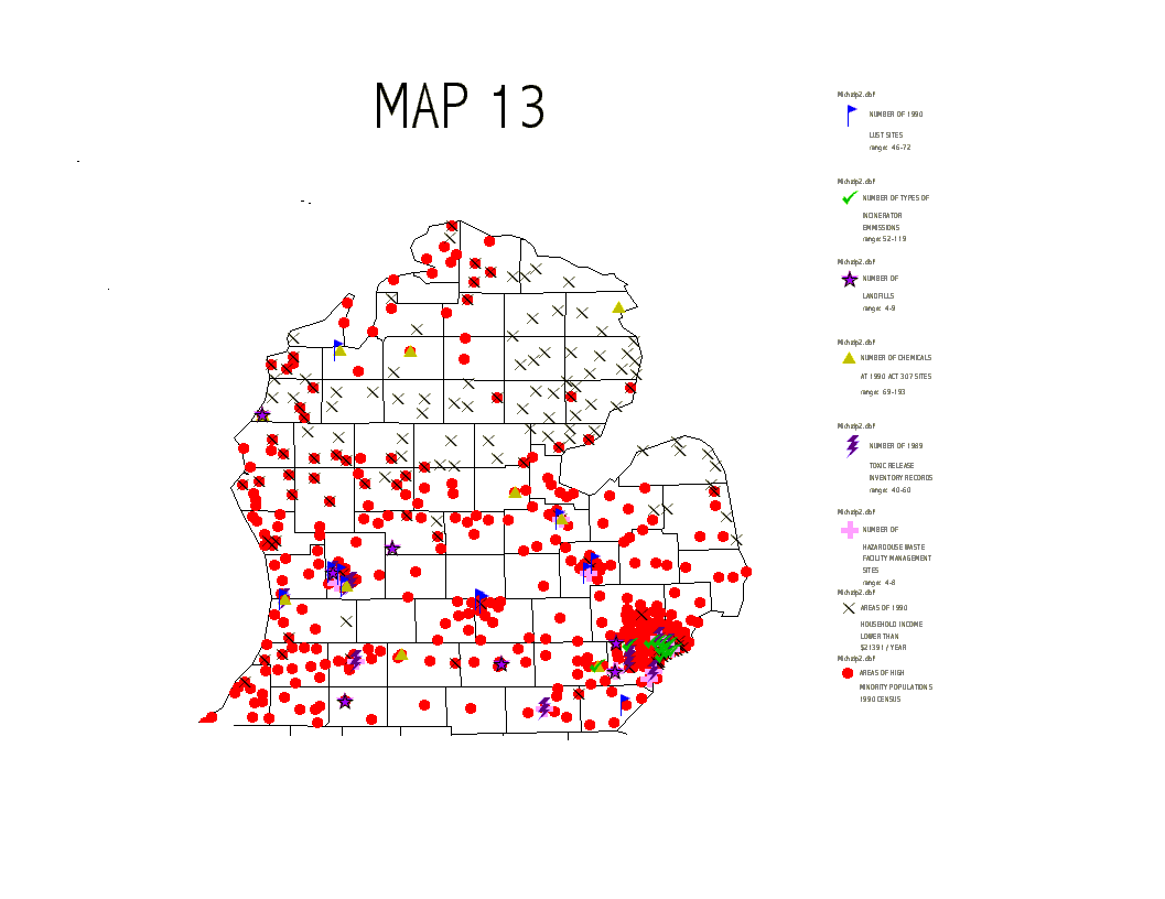 Similar cumulative impacts
can be seen in a close-up map of the Detroit area.
Similar cumulative impacts
can be seen in a close-up map of the Detroit area.
 Conclusion
The disproportionate burden of environmental hazards that minorities and some low-income communities experience is obvious. Arguments and legal challenges regarding environmental racism and the intentional or unintentional siting of environmentally hazardous facilities in minority communities will undoubtedly continue. These are cases that need to be determined on the merits of each individual case. However, there needs to be a mechanism established to prevent future cumulative impacts or disproportionate impacts from new or relicensed facilities.
The Region V US EPA Superfund Division currently uses the following decision matrix to determine priorities cleanups in situations with environmental justice criteria (US EPA, 1997).
| High Minority Population | Low Minority Population | |
| Low Income | Category 1
Highest Level of Action or Priority |
Category 3
High Level of Action or Priority |
| High Income | Category 2
High Level of Action or Priority |
Category 4
No Extra Action Taken |
While the data used in this study would not support decisions based
on low income or high income (except in the case of incinerator records)
a similar decision matrix or decision process could be developed to incorporate
the information on based on levels of minority population and cumulative
amounts of environmental hazard variables. For example, the DEQ could develop
and follow a decision making process for new permits or renewals at environmentally
hazardous facilities by zip code as outlined below:
| BY ZIP
CODE |
3 or more top environmental hazards | 2 top environmental hazards | 1 top environmental hazard | no top
environmental hazards |
| High Minority
Population
|
moratorium on new permits or renewals for hazardous waste management facilities | 5 year moratorium on new permits and renewals only for facilities with an approved pollution reduction plan | 2 year moratorium on new permits and renewals only for facilities with an approved pollution reduction plan | new permits only for facilities with an approved low emissions application |
| Low Minority
Population
|
5 year moratorium on new permits and renewals only for facilities with an approved pollution reduction plan | 2 year moratorium on new permits and renewals only for facilities with an approved pollution reduction plan | new permits only for facilities with an approved low emissions application | standard
permitting process |
Currently US EPA has begun to use GSI in identifying and prioritizing environmental justice concerns. Only in one region, however, is any attempt being made to address the cumulative impact of multiple environmental hazards. Region VII of US EPA has completed the GIS mapping for the city and county of St. Louis and has identified and located all industrial facilities subject to RCRA, CERCLA, UST, LUST, the Clean Air Act, and TRI on a series of GSI maps. The Region has also included blood lead information and plotted this information on a map. The Region overlaid this information with socio-economic data on poverty levels and racial makeup obtained from the Census Bureau in an effort to identify potential areas of environmental justice concern (US EPA, GIS, 1997). At present, though, this information is not yet being applied in any type of permitting or review processes.
There are clearly limitations with such a decision matrix presented above and US EPA efforts, yet they represent a beginning. There will no doubt be economic challenges to such processes given the limitations that they set. Yet, something must be done to restructure the environmental injustice burdens that minority communities face. New protocols must be established that are in line with the uniform regulations and environmental standards that exist in federal and state law.
Literature Cited