![[Click here for generalized picture of alluvial fill in aquifer]](basin_fill.jpg)
![[Click here for Basin and Range Aquifer in Pima County only]](pima_aquifer.jpg)
Introduction
Communities in the southwestern United States face today the prospect of serious water shortages in the near future. Many water conservation efforts concentrate their focus around increasing the efficiency of current water supply systems, while also hoping to reduce water consumers' demands on the system. But solutions that advocate for limits to growth in these communities run counter to the liberal philosophy that pervades the U.S. free market system (Cahn, 1995). It would indeed be deeply "un-American", if not illegal, to build a virtual fortress around a city and refuse any entrance to more people and more economic development, even if such isolationism were intended to protect the walled community from depleting vital resources. And yet cities in the southwestern United States are running up against walls of their own: they are encountering natural limits to growth in the form of depleted aquifers. Tucson, Arizona has drawn from groundwater sources beneath the city for the entire 20th century, and for much of the latter half of this century, many people have been aware of the limitations to ground water supplies. But it has been only during the last two decades that government has begun to ask a critical question: what can be done to avoid hitting the groundwater supply's natural limit? This question is complicated by the significant population increase in Tucson and its neighboring townships in Pima County. It is complicated even further by the fact that the growth engine that drives free-market enterprises runs counter to the limited development inherent to sustainable growth (Cahn, 1995; Hawken, 1993).
The problem is not unique to Tucson, Arizona. Its water crisis represents
a small piece of the world picture where growing communities are trying
to guard against future water shortages:
Water crises in the southwestern United States should not be looked upon as problems to be suffered and solved only by the people who have chosen to live there, but instead as an opportunity for all U.S. cities to learn from. The water management choices and innovations made in southwestern cities like Tucson may be the testing ground for future water practices all over the United States. If the governments, businesses and citizens in Tucson and Pima County can successfully learn to manage and reverse the path of their water crises, the region may become a model for thousands of other communities.In the wake of burgeoning populations, water development is being driven
beyond the absolute limits of guaranteeable supplies and past the point of long-
term sustainable livelihoods, thus, preparing the ground for future crises
throughout the world (Roberts, 1993).
This paper seeks to explain the transitions that the communities in Tucson and surrounding Pima County will experience as it approaches the natural limits to groundwater supplies in the aquifers under the region. While water quality issues figure prominently in the decision-making process of Tucsons water management leaders, this paper focuses specifically on the transitions related to water supply, not quality. Some general hydrological concepts and dynamics will be laid out, after which the population transition in the region will be discussed. The paper will then describe the characteristics of water demand in the region, and the possible effects of population growth upon that demand. An exploration of the possibility of a political transition will then be presented. Finally, the paper will discuss policy solutions and other recommendations.
Theoretical Framework
This paper explores the changes taking place in Tucsons aquifers and in the larger Tucson community in the context of theory about transitions. This paper defines "transition" in the spirit that Drake has used, describing "a specific period of time which spans the shift from slow to rapid change in the sector and then usually a return again to relative stability" (Drake, 1993). Drake notes that not just one transition, but a "family of transitions" can be identified where great change is affecting the population-environment dynamic. That is to say, transitions in different sectors occur in relation to one another. This paper explores the family of transitions occurring in the hydrological, demographic and political sectors. The importance of examining families of transitions is revealed when one considers the limitations of "societal adaptive capacity," with the understanding that increased rates of change as well as multiple changes can make communities more vulnerable to those changes (Drake, 1993). The interaction of transitions and the scale of transitions have, Drake points out, further implications for how to describe change, and how to measure the impact of change on societies (Drake, 1993). This paper will seek to frame the water crisis in the Tucson region in these terms with the intent to identify interactions between transitions and the impact of this resonance between sectors in transition on the Tucson community.
Geography and Water Resources in the Tucson Region
Arizonans pull water from a variety of sources. Mountainous regions provide snow run off; monsoon seasons fill many of Arizona's dry "washes" or stream beds with a seasonal surge of water; the Colorado River, running through the Grand Canyon and south along Arizona's western border, provides water via the "Central Arizona Project" CAP. But the most significant source of water for Tucson, Arizona lies underground in a vast system of rock, gravel, sand and water called "aquifers."
Hydrological Terms and Concepts
The term "groundwater" may be interchanged with "aquifer," although "aquifer" generally implies a large, usable source of groundwater. Water that percolates into the ground slowly works its way through gravel, sand, silt and clay layers (alluvial deposits), filling each pocket of space between ever denser layers of earth. Eventually, the water reaches layers of igneous and other rock known as "bedrock," which is mostly impervious to water, and thus serves as a lower limit to an aquifer. The "water table" is the level of water closest to the earth's surface, as defined by the top of the "saturation zone," or the zone in which water fills every pore in the vast layer of alluvial deposit.
[Click here for generalized picture of alluvial fill in aquifer]
[Click here for in further discussion of aquifers on WCCRs homepage]
Much of southern Arizona draws its water from aquifers in the "Basin and Range" aquifer system. The Basin and Range aquifer system, comprised of roughly 400 alluvial basins, extends from the southwest corner of New Mexico, across southern Arizona, through Nevada, Utah and eastern California, and touch southern Oregon and parts of Idaho (Groundwater Atlas, 1995). The structural environment of this aquifer system developed during the Quaternary and Tertiary periods, and is geologically "young" compared to the systems that make up some of the 5 aquifers that neighbor the Basin and Range system in the southwest United States. Aquifers made of Quaternary and Tertiary deposits, then, to be more permeable than those consisting of older, more consolidated fill. The alluvial deposits that house Southern Arizona's aquifers can reach from roughly under 400 feet to sometimes in excess of 10,000 feet beneath the earth's surface. (Cooley, 1973; Groundwater Atlas, 1995) Bedrock in the Basin and Range system is highly variegated, lying not only underneath alluvial deposits, but, in many places, surrounding aquifer systems. A map of water stored throughout the Basin and Range Aquifer appears mottled, like the hide of a cheetah.
[Click here for Basin and Range Aquifer in Pima County only]
Tucsons Groundwater Source
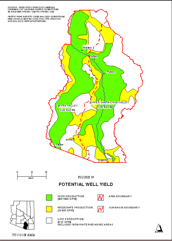
Tucson, Arizona draws all of its water from an aquifer system that lies underneath the city and is a part of a larger aquifer sub-system. Referred to as the Tucson Active Management Area (or Tucson AMA), this area looks like a little like a wishbone, running North to South through Pima County. The area is not coterminous with Pima County, however; people living outside the Tucson AMA pumping area draw from different but adjacent aquifers from the Basin and Range system. The implications for this disjunction between Pima County land use planners and Tucson Active Management Area water use planners will be discussed later. See Figure A below for a picture of the Tucson AMA. At the bottom of the picture, a small silhouette of the Tucson AMA is superimposed on Pima County and the other counties of Arizona.
Dynamics of an Aquifer
While an aquifer system is, in one respect, continuous, one cannot think of it as an enormous flat-bottomed vat from which water withdrawals are evenly distributed. Rather, some wells must be dug deeper than others to reach the alluvial deposits that contain water. Conversely, wells in one area of an aquifer may dry up at the same time that other wells are yielding increased amounts of water. Still, groundwater does slowly flow through the aquifer system, such that withdrawals and recharges in one region can eventually affect the amount and quality of water in another region (Groundwater Atlas, 1995).
"Recharge" is a term describing the process of replenishing aquifers with water, while "discharge" describes the ways in which water is extracted from the aquifer. Natural aquifer recharge occurs in streambeds (streamflow infiltration), at the seam between mountains and flat land (called mountain-front recharge), and also simply through the ground surface. As mentioned above, water can also move from basin to basin, although recharge from inter-basin flow is limited and very slow. Man-made systems can also recharge aquifers through direct injection well sites and through more passive irrigation systems.
Discharge occurs through stream runoff, inter-basin outflow, evapotranspiration (evaporation of water through plants) and, most significantly in southern Arizona, through man-made wells. Tucson (and much of Arizona) has operated for many years in a state of groundwater "overdraft", in which the rate of discharge outpaces recharge.
FIGURE A
Effects of Groundwater Decline
When the water-table drops in an aquifer, one can expect transitions to occur in the hydrology of the aquifer system , as well as in ecological systems that depend upon particular hydrological conditions. Transitions in both of these realms have resultant impacts on societys infrastructure and livelihood. Therefore, each of the effects listed below should be considered not only as individual impacts, but also as events that trigger further changes in a system.
Hydrological Transitions
The hydrological transitions that take place in an aquifer when water tables drop manifest invisibly within the underground structure of the aquifer itself and visibly at the lands surface. Reduced inter-basin and within-basin outflow and inflow occurs at a macro level. The system does not bring in as much new water from other basins and cannot provide as much to others, such that the network of the larger aquifer system is diminished. At a micro level, one discovers that smaller patterns of flow can alter when less water flows through the system (Groundwater Atlas, 1995). Imagine a wave gently cresting over one tide pool, over a small ridge of sand, and into a second tide pool. As the tide ebbs, the amount of water flowing into the first tide pool decreases, and there is suddenly not enough water or inertia to get the waves over the ridge into the second tide pool. This analogy help to visualize the micro directional flow patterns that can change in an aquifer as water levels decline.
Aquifer compaction, land subsidence and earth fissures, the visible hydrological and geological effects of declining water tables, serve as dramatic indicators of shifts occurring underground. Water in an aquifer supports the structure of the alluvial basin. As water within the pockets and crannies of the aquifer system is drawn out, the alluvial fill dries, and the weight of the land above the aquifer cannot be supported. The upper levels of the aquifer system crumble and compress, a phenomena known as aquifer compaction. The impact of compaction on the hydrology of an aquifer presents a negative geometric feedback loop because compaction causes permanent damage to the aquifer, reducing its overall storage capacity. Further, compaction inhibits recharge to the aquifer because surface water cannot as readily penetrate the condensed top layer of the compacted aquifer to deeper regions. The following chart shows compaction relative to water table decline at one well site (Groundwater Atlast, 1995). [Chart of compaction at well site.]
Compaction is evidenced above ground by cones of depression, land subsidence and earth fissures. As sediments of the aquifer dry up and compact, the land sinks. The most severe land subsidence in Arizona has resulted in a 15 foot decrease in elevation, while most highly developed areas experience between 1-5 feet of subsidence and most of remaining land in Arizona has subsided between 0 12 inches (Groundwater Atlas, 1995). Land subsidence leads to the appearance of fissures in the earth's surface, cracking open like the surface of a baked pumpkin pie. These small cracks can eventually open up to become gullies ten feet wide and deep. The picture below shows a gully cutting across an Arizona highway (Groundwater Atlas, 1995). [Earth fissure in Eloy, AZ, 73KB]
Ecological Transitions
Hydrological transitions can perpetrate a host of ecological transitions. The full array of ecological impacts caused by aquifer depletion can only be estimated, since each change in the ecological system can spur change in another system. Roberts lists reduced streamflow, drying streambeds, general vegetation die-off and resultant desertification as being direct results of declining water tables (Roberts, 1993). The water table directly influences stream flow, because saturation at stream bed elevation feeds water into the stream. As the saturation zone falls beneath stream bed elevation, this source of water no longer flows into the stream. Indirectly, then, declining water tables impact riparian habitats that rely upon the water in stream beds. Water table declines also impact vegetation directly. As plants with shallower roots (e.g., grasses) can not access vital water supplies, they die-off, which results in regional desertification and erosion.
Impacts on Society
Hydrological transitions also result in costs to society. As water tables decline and the vertical pumping lift to draw up water increases, well pumps must increase exerted downward pressure to force the water in the aquifer up to the surface. This incurs higher costs for pumping, so ground water mining becomes more expensive as water tables drop. Additionally, land subsidence and earth fissures can damage building foundations, water delivery systems, well casings and sewage systems, which not only impose monetary costs but also threaten water quality and water supply itself.
Public health may also be threatened by the mere fact that depletion of the aquifer can impact water quality. As water levels decline, saline concentrations may increase and total dissolved solid (TDS) concentration and composition change at deeper levels of the aquifer. Chemicals and minerals not found at upper levels of the aquifer may appear in lower reaches and have negative ramifications for public health.
One cannot dismiss the costs of increased conflict between individuals, neighborhoods and regions on the private, corporate and government stage as costs for water, damage to water supply systems and degradation of water quality increases. The cost of the infrastructure loss and the arguments over these costs may weigh as heavily upon society as the scarcity of water itself.
Population Transitions in Tucson, Pima County and the Tucson AMA
Despite, or perhaps because of, the arid climate in the southwestern United States, this region sees sizable rates of growth every year relative to other areas in the country. Growth in these areas during the early 20th century was limited in part by accessible water supplies (or lack thereof). However, improved technology in the 40s and 50s allowed cities to more efficiently tap into the huge volumes of water stored in the aquifers of the southwest, which in turn drew more infrastructure, companies and people to the area (ADWR, 1998; Roberts, 1993). Most of Arizona has seen steady population increases since the 1950s. Maricopa County (home to Phoenix) rated second in the nation for population growth between 1980 and 1986, and third for national growth between from 1980 to 1992 (U.S. Bureau of the Census, 1988, 1994). Tucson has also seen high rates of growth, though its population base is significantly smaller than that of Phoenix.
The following graphs depict population growth in Pima County and Tucson. Historic data for population within the bounds of the Tucson AMA (Tucson metro areas water management district) are not available since this area was politically defined only in recent years. However, predictions for population growth within the Tucson AMA are provided. [Click here for graph of population growth in Pima County during the 20th century.]
FIGURE B (bar graph) and FIGURE C (line graph) follow.
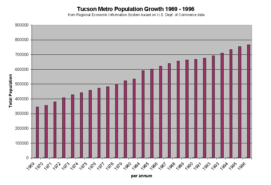
FIGURE B, above: Bar graph of Tucson Population Growth
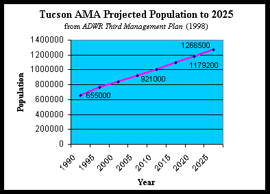
FIGURE C, line graph above: Population growth in the Tucson AMA
As one would expect, both birth rates and migration contribute to population growth in Tucson and the surrounding regions. Migration, however, has accounted for the majority of growth in the area, with a significant portion of migrants originating in other states. While the following data is not complete, it does show that the majority of growth in Pima County has traditionally be attributable to migration into the area.
TABLE 1
|
|
|||||
|
|
|
|
|
|
|
|
Net Migration
|
57%
|
17.90%
|
19.90%
|
7.50%
|
|
|
Natural Increase
|
31.10%
|
14.50%
|
5.50%
|
5.90%
|
|
|
Total Population Increase
|
88%
|
32.40%
|
25.50%
|
19.70%
|
13.40%
|
|
Total Population
|
265660
|
351667
|
443958
|
531443
|
602400
|
A series of articles entitled "The Booming Northwest" (1994) in The Arizona Daily Star, one of the areas major newspapers, interviewed couples new to the area to gain insight into this question. A typical interview profiled older couples, many of them retirees, who chose to move to the area for the consistent sun, warm, dry weather, and the scenery. An analysis of the age structure of the population demonstrates consistent increase in the older population.
TABLE 2
|
|
||||
|
1970
|
1980
|
1984
|
1990
|
|
| 5 and under |
8.1%
|
7.2%
|
7.4%
|
7.5%
|
| 5 - 17 y.o. |
15.8%
|
19.7%
|
N/A
|
17.4%
|
| over 17 |
65.9%
|
61.4%
|
N/A
|
61.3%
|
| 65 and over |
10.2%
|
11.7%
|
12.7%
|
13.7%
|
The strength of the real estate and construction sectors of Tucsons economy provide good indicators of another facet of Tucsons population transition: housing development. Roberts mentions this associated trend in Phoenixs population transition as well (Roberts, 1993). Land that was formerly natural desert or irrigated agricultural crops is now giving way to suburbs and small incorporated towns. The real estate development and construction businesses have done much to determine the spatial distribution of the greater Tucson metropolitan area. Tucsons wide skies and vast desert views create a sense of space that characterizes property development patterns. The booming housing industry has been subjected to increasing permit fees and restrictions, however, in an effort to ensure that development is commensurate with water supply. Still, builders, contractors and developers are most beholden to City and County Planning Departments, agencies that are only minimally involved in the Tucson AMA water management program. As a result, these very agencies that have the most contact with the businesses that impact groundwater withdrawals (developers) seem to focus very little on incorporating groundwater conservation plans, and much more on transportation and sewage infrastructure (Interview #1, 1998; Interview # 2, 1998; Tucson City Planning Department web site, 1998).
Groundwater Supply and Demand
Trends in Arizona State
Lack of accurate and widespread data makes calculations of aquifer water storage for large-scale regions very difficult. Nonetheless, experts report that the aquifer systems in the southern Arizona area used to hold an estimated 900,000,000 acre feet (AF) of groundwater prior to development of wide-scale withdrawal systems (1 acre foot = 325,851 gallons). Wells accounted for about 184,000,000 AF of uptake between 1915 and 1980 (Groundwater Atlas, 1995). The 1940's and 50's saw a surge in groundwater withdrawal due to better pumping technology, cheaper sources of electricity and production pressures from World War II. These growth rates correlate with growth in Arizonas population (Roberts, 1993). Total withdrawal apexed in the 1970's. As a whole, the State of Arizona has seen an overall decline in the use of groundwater since the 1980's, which has been largely attributable to agricultural innovations and changes in crop type. However, growing numbers of people in Arizona's cities have led to an increase in groundwater use in some urbanized areas (Groundwater Atlas, 1995).
The above brief history of groundwater withdrawals during the 20th century brings to light the importance of various factors in the groundwater withdrawal equation, and the dynamic nature of these factors. Firstly, while not surprising, one must acknowledge the serious impact, both positive and negative, that technology has on groundwater use and supply, both directly (better pumping technologies led to higher rates of withdrawal) and indirectly (improved farm irrigation systems allowed farmers to withdraw less.) Secondly, world events lead to changes in production and overall changes in the economy that impact water use, and therefore groundwater withdrawal. Moreover, national policy directives that provide incentives for farmers (or other sectors of the economy) to grow one crop over another (or in some other way change production processes) also impact rates groundwater use. Finally, population increases and decreases impact water supplies.
While it is tempting to believe that the last variable (population) has the most straightforward relationship to groundwater use (it is easy to imagine the relationship as being linear), such an assumption would be fallible. Indeed, recent studies have tested conventional assumptions that water use increases with population and economic growth. But recent longitudinal research by the U. S. Geological Survey showed a drop of 9% in water use across the United States between 1980 and 1995, while population grew by 16%. As reported in the New York Times, the lead author of the report, Wayne B. Solley, stated, "We feel pretty confident in saying that [water use has] stabilized over the last 15 to 20 years." The article indicates that much of the decline can be attributed to increased efficiency in the agricultural and industrial sector, however. In fact, withdrawals in the public sector (public water drawn up by suppliers and distributed to users) showed an increase of 18% from 1980 95 (Stevens, 1998).
Assuming that some kind of relationship exists between population and water use, one must be concerned about two factors. The most obvious is that of population numbers: in Arizona, the number of people in a given area has an impact of some kind on groundwater supplies when maximum efficiency of use has been reached and no gains can be made by reducing consumption in agricultural or industrial sectors. Less obvious is the importance of the spatial distribution of those people. Even though Arizona State's overall rates of groundwater withdrawal went down after 1980, the increasing number of people in urbanized areas could put greater pressure on the aquifer systems in those specific areas. Because aquifers belong to a continuous system, however, the effects of increased depletion in a specific local area can still have wide ranging effects that could impact aquifer systems outside the urbanized areas. Finally, a growing population and a migrating population affect politics, and politics, ultimately, affect resource management. One should be mindful of all of these dynamics when reviewing the specific case of water supply and demand in Tucson, Arizona.
Tucson AMA Water Supply
Sources of water for the Tucson Active Management Area (AMA) water district include groundwater, secondary effluent and reclaimed water, and water from the Central Arizona Project (CAP). The whole of the Tucson AMA relies almost solely upon groundwater withdrawals issued from either private wells or water supply providers that pump from the aquifer throughout the region. According to the Arizona Department of Water Resources (1998), groundwater use in 1995 totaled approximately 307,000 AF.
Effluent water has been used for watering golf courses and other "turf-related" demands, although many water districts do not have reclamation systems in place to make use of effluent. In 1995, about 15% of treated wastewater was distributed for use, amounting to about 9,300 AF. Projects to increase utilization of effluent have not met with swift success, and at present it does not appear that the regions goal to supply 18,800 AF effluent water by 2010 will be reached (ADWR, 1998).
Water from CAP constitutes a potentially significant supplement to groundwater supplies, although for reasons that will be discussed later, CAP water is presently underutilized in the Tucson AMA. The Central Arizona Project channels water from the Colorado River in a canal that runs from the western edge of the state, through central Arizona, Phoenix and Tucson. CAP facilities are designed to deliver water directly to water providers and save unused water in underground storage tanks for later use. CAP water could potentially supply roughly 160,000 AF to the Tucson AMA, although nowhere near this amount is presently used, and providers have only recently begun storing CAP water in the underground storage facilities mentioned above. Although as many as 46,000 AF of CAP water was delivered to users in 1993, use of this source has fallen off dramatically since 1995 for reasons that will be discussed later (ADWR, 1998).
Tucson AMA Water Demand
The Arizona Department of Water Resources measures water demand in three sectors: agriculture users, industrial users and municipal users. A description of these sectors and their use characteristics follows in Table 3, a chart of total water use in each sector since 1985.
TABLE 3
|
|
|
|
|
|||
|
|
|
|
|
|
|
|
| Agricultural |
114,450
|
40
|
93,801
|
34
|
97,180
|
31
|
| Municipal |
115,735
|
40
|
129,444
|
48
|
154,894
|
50
|
| Industrial |
55,744
|
20
|
48,743
|
18
|
60,204
|
19
|
| TOTAL |
285,929
|
100
|
271,988
|
100
|
312,278
|
100
|
The agricultural sector described by ADWR includes farms with two or more acres of irrigated cropland, most of which produces cotton. Total irrigated cropland amounts to roughly 35,000 acres, with stringent restrictions deterring the addition of any more irrigated acreage. The total annual amount of groundwater allotted to all irrigated cropland is 153,258 acre-feet, although not all farms use the whole of their allowance. The allotment was determined as part of a "grandfather clause" in the Groundwater Code passed in 1980. Irrigation systems are typically flood irrigated, with some farms using modified systems to maximize efficiency. According to ADWR, demand for water by the agricultural sector seems to be generally decreasing, though figures for per annum demand vary greatly from year to year, which may be the result of national markets for crops (ADWR, 1998).
Industrial water users include power plants, cooling facilities, sand and gravel facilities, turf-related facilities, dairy operations, and metal mining facilities, all of which use groundwater through industry owned wells. The mining facilities figure most prominently among these users, accounting for nearly 70% of water use by the industrial sector. Turf-related facilities, consisting of golf courses, school yards and cemetery lawns rank second on the list of industrial users. The Groundwater Code of 1980 also grandfathered in members of the Industrial Sector who were active at the time the legislation was passed. This assures the industrial sector a guaranteed allotment of 192,263 acre-feet per year, although the actual use per year has not yet met the allotment. According to the ADWR, the industrial sectors rights to groundwater provide little motivation for user to turn to renewable water supplies. At present, access to renewable supplies is limited and use of these supplies is more costly, contributing to the sector's reluctance to transition to renewable water sources. ADWR authors observe that population and economic growth, among other variables, has and will continue to contribute to increased water demand by the industrial sector, since growth in population and the economy results in new schools, new shopping malls, more golf courses and other development associated with expanding neighborhoods.
The largest water user in the Tucson AMA is the municipal sector, which includes private and public water companies that sell water for all non-irrigation uses. All of the 151 water providers in the region are regulated by a government program, although many are privately owned. Most residents get water from these water providers, although some own private wells.
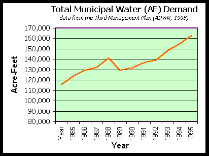
FIGURE B: Total Municipal Demand

FIGURE C: Water Demand by Region in the Tucson AMA
NOTE: 2025 projections assume providers meet year 2000 GPCD targets and new growth meets
SMP new development model rate of 121 GPCD.
For more tables with water use statistics, visit the Arizona Department of Water Resources web page at:
http://www.adwr.state.az.us/AZWaterInfo/InsideAMAs/amatucson.html
Because each water provider serves a different population size and a different mix of user types (for example, business, residential, or institutional facilities for schools, prisons and the military), two different measures of use-rate determine relative consumption per provider. Analysts measure total volume sold by each provider and average gallons per capita per day (GPCD) for the users served by each provider. Although total volume demand may increase, GPCD may drop or remain stable, reflecting increased efficiency in the system. For example, increased use of reclaimed effluent among non-residential users can bring down GPCD numbers. Among residential users, per capita usage varies with water pricing rates, household income, lifestyle, landscaping, age of housing units and the number of persons per household (ADWR, 1998).
Figures B and C show water demand by volume for the Tucson AMA and by region, and Table 4 and Figure D show use per capita in different service regions. Figure C represents the projected increase in water demand for each of the Tucson metro regions and surrounding incorporated areas in the Tucson AMA. "Central" includes the oldest and densest area in the AMA, while "Marana", and "Southeast" have traditionally been less developed regions. However, these smaller areas are experiencing a great deal of growth in recent years, and expectations are that population and water demand in these areas will continue to grow rapidly. The chart shows an increase in water demand of 452% for Marana by the year 2025, a 440% increase for the Southeast, and an 89% increase for Green Valley, while the Central area expects to increase its demands by only 10%. Compared to 1994's total municipal water demand of 139,954 AF, a total increase of 47% to 205,211 AF is expected by 2025. In 1985, groundwater comprised 97% or 112,655 acre-feet of water sold by providers, and in 1995 groundwater comprised 95% or 147,080 of use. The Tucson Water Company is the major service provider in the Central region, and is the largest service provider in the Tucson AMA, and, volumetrically, uses the most groundwater. However, it's GDPC is lower than that of most other providers, in part because of the type of users it services, and in part because it is the only provider with a reclaimed water distribution system (ADWR, 1998).
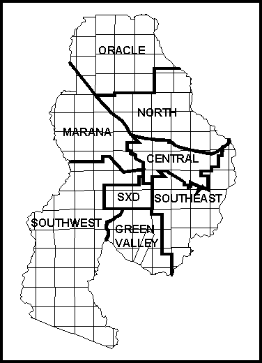
FIGURE D: Regions in the Tucson AMA
Table 4: Use per capita by region
|
|
1994 Potable Total GPCD | 1994 Res. GPCD | 1994 Non-Res. GPCD |
| Central |
|
|
|
| North |
|
|
|
| Marana |
|
|
|
| Southeast |
|
|
|
| Southwest |
|
|
|
| Green Valley |
|
|
|
| Oracle |
|
|
|
| Average |
|
|
|
In sum, water use patterns in the Tucson AMA continue to strain the capacity of the aquifers underlying this region. Eventual aquifer depletion can be the only result if these patterns continue. 1995 estimations of all groundwater use in the Tucson AMA showed an increase of 41,700 AF since 1990, for a total groundwater withdrawal of 307,000 per year. Given an assumed total recharge rate (natural and incidental recharge) of 143,100 AF in 1995, ADWR calculated that "overdraft" of the water budget amounted to 163,900 AF that year. The agricultural, industrial and municipal sectors must somehow all find room in their water use patterns for reducing demands upon groundwater supplies.
Of the Tucson AMAs agricultural, industrial and municipal sectors, the municipal sector is presently undergoing the greatest transition and will have the greatest impact on future water supply and demand. In many respects, the municipal sector is also the least predictable factor in the water budget. Because the total amount of agricultural irrigated land in the Tucson AMA is in decline since acquisition of land for irrigated farming is now tightly restricted, the agricultural sectors contribution to water demand holds no surprises. And while mining and other industries demonstrate variable use patterns, their projected level of use is easier to predict because they have grandfathered rights to groundwater use and they pump through their own wells rather than being subject to service provider price fluctuations and infrastructure developments. Thus, planners can assume that grandfathered industry will continue to use groundwater to supply nearly all its water needs. The municipal sector, on the other hand, is experiencing increased usership as well as increases in infrastructure and changes in infrastructure distribution, largely due to residential and commercial development in formerly sparsely populated or agrarian regions. The municipal sector will assuredly impact the future water budget greatly, but the nature of this impact is difficult to characterize. It will depend upon the type and strength of regulations stipulated by water management organizations like ADWR; it will depend upon water providers decisions to incorporate CAP water and/or reclamation systems; and it will depend upon water users themselves.
Water Management
Historic Legislation
By 1980, the conditions perpetuating severe groundwater withdrawal overdraft throughout Arizona were widely recognized, and legislation that would attempt to rectify this situation was passed. This legislation, the 1980 Groundwater Code, stipulated long-term management and conservation of Arizona's groundwater supplies. Some of these regulations effected immediate change in policies that had historically enabled unfettered development of groundwater resources. One significant measure prohibited further development of irrigated farmland, since farmland irrigation depends upon large water resources. Another measure required that any new subdivision development had to be accompanied by proof of 100 years reliable supply of water (now called Assured Water Supply or AWS). The Groundwater Code also called for strict monitoring and reporting of groundwater withdrawals, which had not previously been performed with consistency and accuracy. Additionally, the Groundwater Code created a management plan, strategies, and goals, and established the Arizona Department of Water Resources (ADWR) as the central organization to carry out these goals.
Arizona Department of Water Resources: Policies and Plans
The Arizona Department of Water Resources (ADWR) "administers state laws, explores methods of augmenting water supplies to meet future demands, and works to develop public policies that promote efficient use and equitable allocation of available water supplies" (ADWR, 1998). This governing body has focussed its activities in five "Active Management Areas" (AMAs), of which the Tucson AMA is one. The primary goal of the Tucson AMA is to achieve "safe-yield" by the year 2025. A safe-yield goal requires that groundwater withdrawals match aquifer recharge, such that the AMA will no longer be operating in overdraft and groundwater supplies will stabilize. To attain this goal, ADWR has outlined five management periods. These periods provide a structure for the review of policies and progress towards the safe-yield goal every 8-10 years. Most of the information regarding water supply and demand in the Tucson AMA comes from the recently drafted Third Management Plan (ADWR, 1998).
Unfortunately, ADWR's attempts to reach the incremental goals that will enable safe-yield by 2025 have not gone according to plan. Some of the proposed strategies for reducing groundwater consumption will be put forth here with a discussion of how these plans have gone awry.
ADWR water management focuses on augmenting water supplies with renewable sources, and conserving and restricting use of non-renewable sources. As has been described earlier, agricultural and industrial users' rights to large annual allotments of groundwater were grandfathered into the 1980 Groundwater Code, which means that as long as these users do not consume over their allotments, ADWR cannot enforce adherence to any conservation programs. However, ADWR has tried to encourage greater use of renewable supplies in these sectors.
ADWR efforts to reduce groundwater withdrawal by the municipal sector revolve around helping providers and users reduce per capita water consumption (GDPC), employ conservation practices and maximize effluent and remediated water use. Reducing per capita water consumption must occur at the point of the water service provider. As mentioned earlier, per capita use can vary greatly depending on the make-up of the water providers service region and the demographics of residential users. Water providers servicing regions with old homes versus new homes, large families versus small families, and low versus high incomes would face different challenges when trying to reduce GDPC. Additionally, the age of the water distribution infrastructure relates to its efficiency and also impacts GDPC rates. Finally, large providers are able to create more efficiency in their systems than smaller providers. For all of these reasons, ADWR has found that setting a flat GDPC rate target is an ineffective goal for water providers (ADWR, 1998). As a result, ADWR has spent energy revamping those standards, rather than forcing water providers to all meet the same GDPC goal. While reconfiguring these regulations makes sense, it has also resulted in fewer gains made in reducing GDPC than originally thought possible.
The 1980 Groundwater Code specified that land developers must prove that land to be developed has an Assured Water Supply (AWS) for at least 100 years. If guaranteed supplies cannot be demonstrated, the land cannot be developed. The problem, however, is that if the developer can show that water is being replenished somewhere in the aquifer, whether or not in the immediate vicinity of the land to be developed, the permit can still be obtained. This, too, has resulted in fewer conservation gains than expected.
Remediation and effluent water have also been underutilized. Again, this is largely due to a lack of infrastructure to purify and distribute these renewable water sources. As long as groundwater remains inexpensive and economic incentives for using renewable resources remains low, these sources will probably continue to be underutilized and a significant component of ADWRs safe-yield program will not be achieved.
Central Arizona Project: An Untapped Solution?
In 1963 the Supreme Court ruled, in an historic case between the Arizona and California, to allot Arizona 2.8 million acre-feet of Colorado River to Arizona. The problem then facing Arizona was that of distributing the rivers water, which runs through the northwestern corner of the state, and then south along its western border. After a period of design, planning, and great debate, the Bureau of Reclamation began building the Central Arizona Project delivery system. Funded through Federal loans, the project constructed concrete lined canals, siphon tunnels, pumping plants and pipelines, a system which now stretches from the Colorado River at Lake Havasu, to the center of Arizona through Phoenix, and south to Tucson where the project terminates. The canal winds through 336 miles of desert with storage facilities and distribution infrastructure points placed intermittently along its banks (Bureau of Reclamation, "CAP" poster, c. 1980s).
[Click here for an superb aerial view of CAP (18KB)]
[Click here for a picture of CAP, close-up, 14KB]
[Click here for one more close-up of CAP, 13KB]
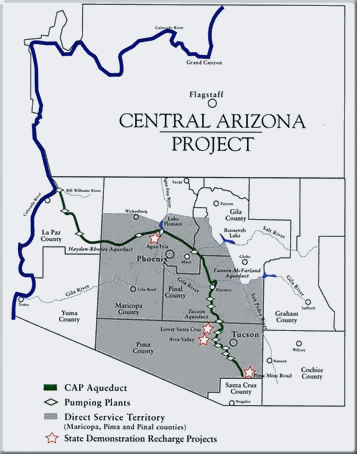
FIGURE E: Map of the CAP Project from CAP web site.
From its incipience, CAP has instigated controversy. While the details of the ire raised by CAP will not be discussed here, one can immediately recognize both the water rights issues as well as the ecological and hydrological issues that CAP has stirred up. For example, the system is designed to provide water specifically to the densely populated areas of the state, although it traverses land connected to less populated communities. At the same time, the eco-geological divide that the canal presents to flora and fauna is problematic, despite the "wildlife crossings" that have been built at intervals across the canal. Also, the systems design raises questions about the impact of evaporation off the canal as water travels its 336-mile expanse under the desert sun.
Nonetheless, CAP is viewed by ADWR and other water resource organizations throughout the state as a necessary component of a water management program. This assumption seems reasonable if one considers the significant reductions the Phoenix AMA has made in its groundwater uptake after heavily implementing CAP water distribution (Roberts, 1993). Moreover, the basic CAP distribution centers have already been built in the Tucson AMA, so CAP water is already flowing to the area. Why, then, isnt the Tucson area using this significant source of renewable water?
In the 1980s, the Tucson water providers and water resource managers were slow to develop additional infrastructure to deliver CAP water to users, in large part because they had little economic incentive to do so. By the early 1990s, however, this infrastructure was built, and by 1995 the Tucson Water Company (TWC) finally brought CAP water on line to a large portion of its service area. Unfortunately, TWC made some critical errors that erupted in public outrage and changed the course of Tucsons water policy. The delivery system for CAP water had not been sufficiently piloted before a large portion of the community received CAP water. When faulty, decaying pipes sent a constant stream of rusty, muddy, smelly water flowing through residents faucets, the community blamed it on CAP water quality problems. According to one source at a water conservation organization in Tucson, a "few" politicians and business leaders, "for reasons of their own", used this event and the communitys temporary alarm to galvanize public sentiment against CAP water for the long term (Interview #1, 1998). The overwhelming majority of citizens voted in Proposition 200, the "Water Consumer Protection Act of 1995" later that year, prohibiting the use of CAP water until it could match the water quality standards of groundwater.
While the Tucson Water Company and ADWR have assured citizens that the distribution network can be fixed and that CAP water is treated to exceed national standards for potable water, it is impossible, even with osmosis treatment, to match the purity of aquifer water. As a result, the Tucson AMA municipality is locked into using groundwater for potable use until at least the year 2000. Meanwhile, CAP water continues to accumulate in storage facilities or discharge into riverbeds. Nominal amounts of CAP water is utilized by non-residential users, and experimental recharge projects have injected up to 33,300 AF annually into the aquifer underlying Tucson, but most of the 138,920 AF of Tucsons CAP water presently goes unused (ADWR, 1998).
Lessons from the CAP Controversy
The CAP water controversy in the Tucson AMA offers a fascinating study of human dynamics with respect to water issues. One surprising dynamic was that the politics of this debate split along unusual lines, as citizens standing in defense of "water quality" conservation argued against entities advocating "water supply" conservation. Regardless of which sides claims were more legitimate, the debate provides a clear example of the choice communities all over the nation may have to face with increasing frequency: Should communities sacrifice water supply to preserve water purity, or sacrifice purity to ensure supply? A study of other U.S. communities that would investigate the emergence of this particular divide within political and institutional organizations would be interesting, and possibly useful for future policy makers.
Moreover, the highly politicized nature of the CAP controversy in the Tucson AMA demonstrates the increasing potential for emotional public debate over water issues. This volatile atmosphere can result in swift and radical policy changes that can determine the future course of water management in communities, as it did in Tucson.
Political Transitions
This author speculates that along with hydrological and ecological transitions, increasing water scarcity may be connected with a third transition. Beyond instigating policy changes and political debates, water scarcity could bring about a political transition. One might identify this transition by measuring increases in citizen issue recognition, increasing momentum behind social mobilization (e.g., people joining advocacy groups), and increasing numbers of advocacy groups mobilizing around water issues. To some extent, this has been apparent in the Tucson AMA. Increasing numbers of articles have appeared in the media about water issues, and greater numbers of citizens and business seem to be forming new water advocacy groups or joining existing coalitions. For example, the Tucson Regional Water Council has been gaining support from business leaders and citizens as it tries to create a venue for discussion of water issues in the Tucson community. For more information about TRWCs activities and a fascinating review of Tucsons water issues, visit their web site. http://www.azstarnet.com/~twrc/
If one characteristic of a transition is increased vulnerability of the community undergoing transition (Drake, 1993), the CAP water history may serve, this author argues, as an example and harbinger of a political transition. As communities have to make increasingly difficult choices about water management, those choices may be marked by heightened tension between stakeholders. This heightened tension may lead to increased politicization of the water issue under debate and therefore increased polarization of stakeholders. One may find that increased politicization of the issue and polarization of stakeholders leads to simplification or reduction of the issue at hand, which inevitably leads to less rational decision-making. As water quality and water supply becomes more jeopardized, communities need to make increasingly rational (if difficult and sometimes radical) decisions about their water resources. If, instead, the political climate surrounding water issues is volatile, communities may be more at risk of making irrational decisions that will increase the vulnerability of both the water resource and the community. In the case of the Tucson AMA, high rates of population in-migration introduces yet another factor into this equation, all though the specific ways in which in-migrators might interact with and affect the heightened political debate around water issues is hard to predict. Therefore, this author believes that there is a resonance between population transitions, hydrological and ecological transitions and political transitions, and that they ways in which these transitions interact ultimately affects future water resources.
Policy Recommendations
ADWRs Third Management Plan aims to continue its program towards conservation (reduction at the level of GDPC) and integration of renewable sources of water into public use. The plan specifies that, ultimately, the Tucson AMA will have to incorporate CAP water into its water management practice. Still, even if CAP water comes to figure prominently in Tucsons water resources, CAP water resources are not infinite. Water management experts predict that CAP water levels will begin to decline in the early half of the 21st century (ADWR, 1998; Roberts, 1993). Therefore, the Tucson community needs to find completely different means of ensuring water supply for the long-term future.
This author argues that population limits must be determined. While untapped efficiencies in water management remain, and it is still true that population can grow without increasing overall demand, once those communities are operating under maximum efficiency, groundwater withdrawals will continue to escalate as the population grows. Still, other factors may make Tucsons water situation untenable even before population would be the dominant factor in this equation. At present, Tucson needs to focus on increasing efficiency. This includes, as ADWR advocates, developing infrastructure and policies that will greatly increase the use of effluent and reclaimed water, as well as CAP water. Additionally, citizens need to be educated to make further reductions in their use of water. Indeed, industrial level reclamation technology could be applied on a small scale to be used in homes. This author envisions mini-effluent catchment machines, stored in the home, that would cycle used water through a cleaning process and then re-deliver it to a water tank. Thus, homes would have two water tanks: one that stores potable hot water, and one that stores cleaned, reclaimed water. Ultimately, however, the only incentive for consumers to make radical changes would be economic. The closer Tucson comes to depleting its aquifer resources, the higher the cost of water will become. Harding calls this scramble for the last of resources "the tragedy of the commons." Tucsonans can wait for the free-market to determine the cost of water, at which point declines in aquifer levels may not be recoverable, or they can self-impose strict price structures now, before the water is gone.
Conclusion
Tucson and its surrounding region has seen a great deal of growth in its population, residential expansion and groundwater development during the 20th century. The latter decades of this century have brought evidence of hydrological and ecological transitions to this area as a result of the huge demand placed on the regions aquifer system. The government and the citizenry of the Tucson AMA have come to recognize that their present water budget overdraft is unsustainable. Policies and innovations to bring the Tucson AMA into a state of safe-yield have had some impact, but goals to balance the water budget by 2025 seem increasingly difficult to achieve. Because consumers lack economic incentives to break with groundwater mining practices, and because political conditions have made alternatives to groundwater more difficult to implement, policy makers are having difficulty making significant headway towards the safe-yield goal. This author observes that the Tucson AMA will only achieve safe-yield through drastic but rational change at the policy level, the water provider service level, and the consumer level. This would entail stricter water management policy, more coordinated regional planning to curtail population growth, large and home-scale reclamation water system development, sharp increases in pricing structures, and radical behavior changes among consumers.
This paper has also explored the possibility that political transitions
occur where scarcity of resources like water are felt more acutely by communities.
These political transitions, characterized by an increasingly volatile
politicized atmosphere, increasingly polarized stakeholders, and increasingly
reductionist and irrational solutions to complex resource management problems
puts communities at even further risk for future resource problems. Future
explorations of the politicization of water issues, as well as an examination
of a political transition with respect to environmental issues are recommended.
Other helpful web sites:
http://www.acwanet.com/waterlinks/index1.html#anchor1480933 helpful water links-general
http://www.azstarnet.com/~trwc/ Tucson Regional Water Council
http://www.ag.arizona.edu/AZWATER/ Water Resources Research Center
Arizona Department of Water Resources, Draft of Third Management Plan: 2000 - 2010, Tucson Active Management Area. Phoenix: Arizona Department of Water Resources. 1998.
Arizona Department of Water Resources web site: http://www.adwr.state.az.us.
Bureau of Reclamation, "Central Arizona Project." Poster. Washington D.C.: U.S. Department of the Interior. c.1980's.
Cahn, Matthew A., Environmental Deceptions: The Tension Between Liberalism and Environmental Policymaking in the United States. Albany: State University of New York. 1995.
Central Arizona Project web site: http://www.cap-az.com/download/files/map.jpg
Cooley, M.E., "Map showing distribution and estimated thickness of alluvial deposits in the Tucson area, Arizona." (Map I-844-C) Folio of the Tucson Area, Arizona. U.S. Geological Survey, Department of the Interior: 1973.
Drake, William, "Towards Building a Theory of Population-Environment Dynamics: A Family of Transitions" in Population-Environment Dynamics, ed. Brechin, Drake, and Ness. Ann Arbor: University of Michigan Press. 1993.
"Ground Water Atlas of the United States: Segment 2, Arizona, Colorado, New Mexico, Utah", Hydrologic Investigations Atlas 730-C. U.S. Geological Suvey: Reston, VA. 1995.
Hawken, Paul, The Ecology of Commerce: A Declaration of Sustainability. New York: HarperBusiness. 1993.
Interview #1: Marnie Boardman interviewed a member of a local coalition for Tucson's water interests in November, 1998. (source does not wish to be named for politically sensitive reasons.)
Interview #2: Marnie Boardman interviewed a water management professional with Arizona Water Resources Department in November, 1998. (source does not wish to be named for political reasons.)
Interview #3: Marnie Boardman interviewed a demographer at the University of Arizona in November, 1998. (source did not wish to be named.)
Regional Economic Information System web site: http://fisher.lib.virginia.edu/reis/
Roberts, Bruce R. Water Management in Desert Environments: A Comparative Analysis. Berlin, Germany: Springer-Verlag. 1993.
Stevens, William, "Expectation Aside, Water Use in U.S. Is Showing Decline," New York Times, Nov. 11, 1998.
Tucson Planning Department web site: http://www.ci.tucson.az.us/
U.S. Bureau of the Census. County and City Data Book, 1967. Washington D.C.: U.S. Government Printing Office. 1967.
U.S. Bureau of the Census. County and City Data Book, 1972. Washington D.C.: U.S. Government Printing Office. 1973.
U.S. Bureau of the Census. County and City Data Book, 1977. Washington D.C.: U.S. Government Printing Office. 1978.
U.S. Bureau of the Census. County and City Data Book, 1983. Washington D.C.: U.S. Government Printing Office. 1983.
U.S. Bureau of the Census. County and City Data Book, 1988. Washington D.C.: U.S. Government Printing Office. 1988.
U.S. Bureau of the Census. County and City Data Book, 1994. Washington
D.C.: U.S. Government Printing Office. 1994.
![[Click here for an superb aerial view of CAP (18KB)]](images/cap027.jpg)
![[Click here for a picture of CAP, close-up, 14KB]](images/cap018.jpg)
![[Click here for one more close-up of CAP, 13KB]](images/cap019.jpg)