The Reconquista River basin extends towards the north and northwest of the Metropolitan Area of of Buenos Aires (MABA), with a total area of 1.670 km2 and a population of approximately 10% of the country's population (Black&Veatch Int. Co. et al., 1996). The basin covers almost the whole of the municipalities of San Fernando (100%), Morón (96%) and Moreno (91 %), y partially Luján (19%), Gral. Rodríguez (81%), Gral. Sarmiento (54 %), Tigre (15%), Gral. Las Heras (39%), Merlo (59%), Tres de Febrero (63%), San Martín (70%), San Isidro (73%), Vicente López (10%) and Marcos Paz (29%).
Down-river of the Ingeniero Rogger dam, the Reconquista's main affluents are the creeks Sauce, Torres, Las Catonas, Los Berros, Morón y Basualdo. It finally divides in the Canal Aliviador and the Tigre River, discharging later to the Luján River.
The Reconquista River is a natural limit between two sub-regions with different land-use and service infrastructure. On the right margin of the river, and in radial direction towards the City of Buenos Aires (the Federal District, and the core of the MABA), we find the highest population densities, with consolidated urbanization and service infrastructure. On the left margin, concentrates the low-income population, and the service infrastructure is scarce and discontinuous. Along the river, the Ingeniero Roggero dam marks the limit between the higher basin and the medium and lower basin. In the higher basin rural activities are predominant, population densities are lower and there is reduced industrial activity. In the medium and lower basin, rural activity decreases until disappearing in the lower basin. In this section, industrial activity is predominant and population density is high, especially near the mouth of the Morón creek (Black&Veatch Int. Co. et al., 1996).
The location of this water course, in addition to the radial structure of road and rail networks centered in the Federal District, has favored the installation of big industries in the last few decades. Urbanization and smaller industries followed. A generalized reduction of around 11% of industrial activity in the Province of Buenos Aires is observed from the data provided by the National Economic Census of 1985 and 1994. In the area, this is seen especially affecting the smaller industries, and the textile and metallurgic activities. On the other hand, there is a proliferation of industries that require a low initial investment, like the chemical and pharmaceutical industries (Black&Veatch Int. Co. et al., 1996).
The basin also counts with big open areas of national jurisdiction, such as military facilities (in Gral. Sarmiento and Morón) and landfills. There are other areas with low population densities in Morón and Gral. Sarmiento as well (Black&Veatch Int. Co. et al., 1996).
The area is served by sewage systems provided by the Province (AGOSBA) and by the firm Aguas Argentinas, operator of the concession of the federal service. This company serves the municipalities of Morón, Tres de Febrero, Gral. San Martín, San Isidro, Tigre and San Fernando, while AGOSBA serves Merlo, Moreno and Gral. Sarmiento. The average level of service is only 21,2% of the total area of these municipalities (Black&Veatch Int. Co. et al., 1996).
The Puelche Aquifer
The provincial's main water supply is a multiple aquifer formed by various productive layers. The main aquifer is the Puelche Formation, at variable depths in all the MABA. Above this formation, there is a series of productive levels, which are generally called the Epipuelche, of which the most superficial is the water table. Below the Puelche, there is the Hipopuelche, with high salinity, for which is only used for recreational purposes in most cases and for industrial use in the most stressed areas (Black&Veatch Int. Co. et al., 1996).
Some characteristics of the Puelche aquifer were described by Santa Cruz et al (1997):
This aquifer is lens-shaped, 50 km wide, extending next to the Paraná river, and probably circulating along the axis of some ancient similar basin or parallel to the Paraná. Maximum extraction rates can be 150 m3/h, and usually range between 20 and 100 m3/h in industrial areas with good specific flow, if well casing is in good condition (Jorge Santa Cruz, 1997). Water is potable. Recently, normal nitrate values have increased, due to contamination originated in deficient well construction and sanitary systems. The direction of flow of the water table generally migrates perpendicular to the Paraná river following the course of the creeks that derive to the Plata-Paraná system, whereas the Puelche apparently migrates parallel or subparallel to the Paraná, ending in this river.
Main Environmental Problems Affecting Water Use in the Reconquista River Basin
Water Quality of the Reconquista River
The concentration of human activity has produced the pollution of surface water in the middle and lower areas of the river, deteriorating its self-depuration capacity and making it inept for almost all its possible uses. There is also a synergistic effect of environmental degradation with the combined action of flooding, which exposes pollution to a broad sector of the population not normally suffering from it (Black&Veatch Int. Co. et al, 1996).
Water quality decreases towards the lower areas of the basin, starting from the Ingeniero Roggero dam, as it flows through the metropolitan area. The greatest levels of pollution are found at the mouth of the Morón creek. The levels of pollution decrease once again at the river's mouth, due to tides causing a reverse flow from the Luján River, which enhances water oxygenation. Pollutants present in the surface water are bacteriological, heavy metals, detergents, phenols, BOD, and fats (Black&Veatch Int. Co. et al, 1996).
Groundwater Quality in the Reconquista River Basin
The productive aquifer in the MABA has always been the Puelche, constituted by sands of fluvial origin, excellent water quality and good extractive flows. Nevertheless, since the great population and industrial expansion, beginning in the 1940s, the volumes extracted have greatly increased to over-exploitation, causing a destabilization of the hydrological system in a wide area. This destabilization can be summarized in the following way (Black&Veatch Int. Co. et al, 1996):
Sources of pollution
The Reconquista river presents high levels of pollution, originated in the various activities and land uses of the different parts of the basin, in most part due to domestic and industrial discharges. Discharges to the river are asymmetrical, and are much higher on the right margin of the river than on the left. This is mainly because of the greater urban and industrial development on that margin, with the exception of the industrial area of Bella Vista (Gral. Sarmiento) on the left margin. There are also illegal industrial and sewer connections to storm-water systems that discharge untreated effluents to the river (Black&Veatch Int. Co. et al, 1996).
The problems with sanitary service
Services have not expanded at the same rate that population (Brunstein, 1988). Population with no piped water obtains the water through perforations, usually to extract water from the Puelche. Nevertheless, it would seem that the poorest population would only reach the water table, given that it is nearest the surface and less expensive to exploit. This water table is almost completely contaminated throughout all the region of Buenos Aires, and the population does not always know this. In addition the low-income population tends to settle in areas subject to flooding, where the water table is very near the surface, and easier to exploit. When the low-income population does manage to access the Puelche, it cannot adequately control the contact with the water table, contaminating both the water extracted and the aquifer. Other populations, in a much lesser degree, are connected to communal water systems for water supply. In the area of the Reconquista River Basin, these cooperatives usually supply water from the Puelche. Daily drinking water consumption is estimated in 300 liters/hab.day (Brunstein, 1988).
The Puelche is also contaminated for other reasons, particularly by the existence of a great number of septic systems. In highly populated areas, these are very dense, and pollute the underground with nitrates, where the Puelche is semi-confined. In areas with no sewage systems, the answer is septic systems. These are frequently constructed in a precarious way, affecting the quality of the underground water. There are cases of self-contamination within a family, which has a septic tank and a well on the same lot (Brunstein, 1988). Besides the defective operation of these septic tanks, the cleaning up is very expensive, encouraging illegal dumping to storm-water sewers, streets, surface water bodies or the ground. This aspect will be addressed in greater detail in the following section.
In addition, in heavily industrialized areas, the over-exploitation of the aquifer has lead to constant and significant descents in the last 30 to 40 years. In some areas, this means a depression velocity of over 1m per year. This not only makes extraction more expensive, but also uses up the resource and causes an increase of concentration of salts. This, in turn, favors the salination occurring near the river margins, which are already progressing at the speed of 100m per year (Brunstein, 1988).
Domestic Discharges
The most serious problems from domestic discharges occur in densely populated areas with no sewage systems. The waste water discharged either on the land or in improperly sealed septic tanks, generally built above the water table, can cause pollution of the highest layer of the aquifer or of the saturation area (Black&Veatch Int. Co. et al, 1996).
Rural areas (Gral. Rodríguez, Gral. Las Heras, Luján, and Marcos Paz) are characterized by having small percentage coverage of sewage service. Usually, population is dispersed within the municipality, making the connection of the entire population unfeasible. Some of these areas have municipal treatment plants, but in many cases, these do not work well or at all, due to financial problems, low volumes to justify operation or lack of technical staff to correctly operate them. These plants generally discharge to local rivers and creeks. Trucks collect the sludge from the individual users, and fees for this service are usually high.
In more rural/urban municipalities there are some municipal plants that also are working at partial capacity. There is still little sewer infrastructure and little control of illegal discharges.
Urban municipalities still have an important part of the population relying on septic systems. Some neighborhoods have built their own treatment plant. Most discharges end up on the storm-water system or the river, especially in areas with an important low-income population, and there are numerous illegal connections to the sewage provided by Aguas Argentinas. In the municipalities nearer the Rio de la Plata, water table is very near the surface, and contamination from saturated septic tanks is common. Municipal sewage and treatment is not effective, and usually discharge untreated effluents to the river directly or indirectly, and some pollution may also originate in heavy storms, from the reliefs of Aguas Argentinas. Sludge collection is also expensive, encouraging illegal discharges. Aguas Argentinas has expansion plans for most of these areas. Some municipal authorities stress the need for a sanitary infrastructure, especially due to the impact of current discharge on the quality of the Puelche aquifer. Many industries use this aquifer in their production, especially in the manufacture of beverage products. If the aquifer is contaminated, these industries (the municipality's main source of income) might move to other municipalities.
Industrial Discharges
A characteristic of the industrial activity in the basin is that, even within the service area of Aguas Argentinas, the extraction and discharge of water and wastewater is made outside the company's system. This is especially the case for big industries. Given the dispersion of activities and locations, this makes the quantification and qualification of effluents, and consequent treatment control, difficult. Historic information is discontinuous and incomplete (Black&Veatch Int. Co. et al, 1996).
According to the 1985 Economic Census, there are 14,891 industries in the municipalities included in the basin. Most industries correspond to the manufacturing of metallic products, machinery and equipment. Following in number are the food products, beverage and tobacco industries; the textile, clothing and leather industry, and the wood industry and wood products industry, including furniture. Chemical manufacturing industries are also important in the basin.
A more recent study states that there are 12,000 industries in the basin. There is no precise data on the amount of industries affecting the base, or on what their discharges and water consumption might be, in terms of quantity and quality. Generally, effluents from these industries directly discharge to the Reconquista River, its tributaries and to the underground (Black&Veatch Int. Co. et al, 1996).
Industrialization generally accompanies urbanization. The higher areas
of the basin are not heavily industrialized. There are a few agroindustrial
plants, which consume high volumes of water, mainly from groundwater sources.
Some of these municipalities are considering the construction of industrial
parks, to attract industrial activity. The middle and lower areas of the
basin are more industrialized, and the greatest impact is received by the
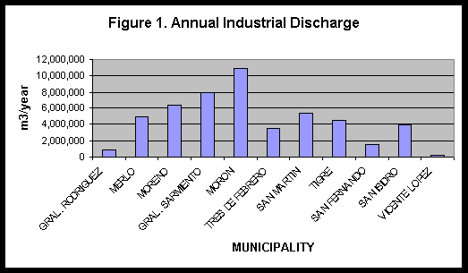
Morón creek (Black&Veatch Int. Co. et al, 1996). Figure 1 shows
the amount of discharge per municipality, where Morón greatly exceeds
the volumes discharged in other communities. The ammount discharged also
indicates how much water is extracted.
In areas with important proportion of low-income population, some dangerous processes in industrial production are hired from smaller industries. These industries do not meet health and safety regulations, and wastes are illegally dumped in waterways, in solid waste dumps and to the storm-water system. Being their main source of income, it is politically unfeasible to close these activities (Black&Veatch Int. Co. et al, 1996).
Industrial activity has changed with time, mainly due to economic development. There has been a shift in the predominance of certain types of activity, the size of industry and the processes. Where industries produce exportable products, their processes must meet certain international standards that include environmental quality. Some other industries, though, were established in previous decades, and still have the same processes.
Industries can be grouped by type of effluent discharged. The groups of slaughter-houses, chemical industries and tanneries discharge the greatest flows in the basin. The slaughter-houses, dairy industry and tanneries are the activities that potentially contribute the most with conventional (organic) contaminants. Chemical industries and tanneries, are important in the generation of heavy-metal pollution and in toxic substances (Black&Veatch Int. Co. et al, 1996).
Solid and semisolid wastes
This is another source of pollution, especially originated in the illegal dumping of sludge from septic systems and treatment plants. Percolation from landfills might also be contributing to pollution of underground water resources. Other solid waste may be discharged by industries, causing the embankment of water, increases of the BOD levels and reduction of oxygen diffusion (Black&Veatch Int. Co. et al, 1996).
The illegal dumping of wastes produced by effluent treatment plants is favored by legislation. CEAMSE is the state company covering the collection and disposal of wastes in the area of Greater Buenos Aires. The service only covers reception of stabilized and non-toxic wastes. Furthermore, ashes produced by waste incineration are not accepted. Even though regulation exists, there is not yet the adequate infrastructure for landfilling of this type of wastes. Illegal dumping then causes the same pollution that the treatment plants are trying to avoid (Black&Veatch Int. Co. et al, 1996).
Economic Transitions
Once among the world's most prosperous economies, Argentina experienced slow economic growth from the 1940s until the start of the Convertibility Plan in 1991 (World Bank, 1998). By the mid-1970s long-term growth had declined noticeably, and in the last half of the 1980s, Argentina suffered its longest period of stagnation in the century. Savings and investment rates fell precipitously from the mid-1970s until 1989. Argentines, responding to the unstable macroeconomic environment, increasingly saved and invested abroad. Labor productivity fell and poverty worsened.
Even though in a substantive part of the gross product and employment of the country concentrates in the MABA (Brunstein, 1988), industrial activity has decreased significantly since the mid-1970s. In the same period, nevertheless, commercial activity and services have increased. As was mentioned before, in the Province of Buenos Aires, the decrease in industrial activity has been of 11% in the number of industrial plants in the 1985-1994 period (Black & Veatch et al, 1996).
Demographic Transitions
Population data was obtained for every municipality forming the basin, from Randle (1981). Pilar is also included in the analysis, even though it does not belong to the Reconquista River basin. Nevertheless, its policies for promoting industrial and housing developments might have a significant impact on the groundwater supply.
Figure 2 shows population growth for the communities listed above. The biggest populations are those of Gral. Sarmiento and Morón (around 650,000 inhabitants) (see Table 1 for detailed data). In those municipalities located near the Federal District, a transition phase of population growth started at the beginning of this century. As distance increases away from the Federal District, this transition phase occurs later in time, typically in the 1940s. The rural municipalities (Luján, Gral. Rodríguez, Marcos Paz and Gral. Las Heras) experienced a more gradual population growth until the 1970s, when growth rates increased.
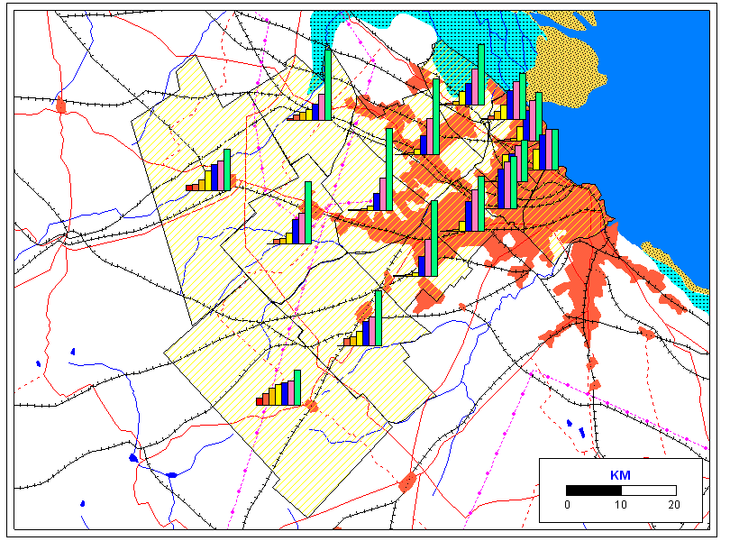
Table 1 - Population Growth in the Reconquista River Basin
|
|
|
|
|
|
|
|
|
| GRAL. LAS HERAS |
2,303
|
3,711
|
5,342
|
6,311
|
6,855
|
7,480
|
10,987
|
| GRAL. RODRIGUEZ |
3,591
|
4,492
|
8,518
|
19,013
|
23,596
|
48,383
|
|
| GRAL. SAN MARTIN |
2,867
|
7,047
|
50,852
|
269,514
|
278,751
|
360,573
|
406,809
|
| GRAL. SARMIENTO |
5,168
|
12,726
|
46,413
|
167,160
|
315,457
|
652,969
|
|
| LUJAN |
10,256
|
12,416
|
20,813
|
38,183
|
51,197
|
58,909
|
80,645
|
| MARCOS PAZ |
3,659
|
4,896
|
7,783
|
12,604
|
15,070
|
29,104
|
|
| MERLO |
2,469
|
3,595
|
6,990
|
19,865
|
100,146
|
188,868
|
390,858
|
| MORENO |
2,329
|
3,278
|
4,836
|
15,101
|
59,338
|
114,041
|
287,715
|
| MORON |
3,488
|
7,880
|
24,624
|
110,344
|
341,920
|
485,983
|
643,553
|
| PILAR |
3,708
|
9,920
|
14,508
|
19,854
|
30,836
|
47,739
|
130,187
|
| SAN FERNANDO |
4,154
|
11,324
|
24,660
|
44,666
|
92,302
|
119,565
|
144,763
|
| SAN ISIDRO |
3,955
|
9,912
|
19,092
|
90,086
|
188,065
|
250,008
|
299,023
|
| TIGRE |
3,329
|
8,978
|
16,691
|
58,348
|
91,725
|
152,335
|
257,922
|
| TRES DE FEBRERO |
263,391
|
313,460
|
349,376
|
||||
| VICENTE LOPEZ |
12,100
|
149,958
|
247,656
|
285,178
|
289,505
|
Between 1945 and 1960, there was an immigration period towards the MABA. This movement was lower in volume and had other characteristics than the immigration of Spanish and Italians before the Great Depression (Jofre, 1993). In this case, the predominance was of immigrants from neighboring countries. They first settled on the frontier provinces, and in a second stage, arrived in Buenos Aires, together with other internal migration flows which had been going to the city since 1938. This movement was caused by the concentration of economic, social and political functions in the area. According to data from the 1980 Census, 25% living in the Federal District was born in the provinces. In the province of Buenos Aires, almost 35% of the population came from other provinces. Torres (1994) explains that between 1940 and 1960, the context was of metropolitan growth based on internal migrations, of substitutive industrialization of importation, and of policies tending to redistribution of income. In this period, there was an important expansion of the periphery. This expansion exceeds the central nucleus and the first ring, already consolidated surrounding the nucleus. In addition, there was an important process of central densification (building in height). The urban workers moved to peripheral areas and a wide range of medium strata moved to the central buildings. The slums, marginal to the market, find vacant land, some central, but mainly in the extensive ring that follows the flood areas of the rivers Matanza-Riachuelo and Reconquista.
During 1960s and 1970s, the metropolitan growth rate decreased, reducing the relative weight of migrations (Torres, 1994). Several of the Federal Policies that affected the processes of urban structuring changed or disappeared (subsidies for homes and transport, rent law). The expansive development of economic lots in the periphery stopped and the submarket of apartments was selective for the medium to high-income levels. During the 1980s, several important changes regarding the central-peripheral tension appeared. On one hand, trends towards deterioration of central areas reappeared, and on the other, in extreme periphery -in areas made accessible by two main highways- developments showed a trend towards suburbanization of the groups of highest socio-economic level. The process of migration from other provinces and countries has slowed down, and migration flows occur between rural areas and capital cities within the provinces (Jofre, 1993).
In Buenos Aires, urban policies were implicit or, when explicit, were not applied in an effective manner (Torres, 1994). The processes of urban expansion were produced in conditions of laissez-faire. This resulted in the consolidation of a discontinuous and unarticulated peripheral urban network, with no provision of services, and generally occupying interstitial areas away from the main axes of transportation, in some cases even in flood plains of the rivers Matanza and Reconquista. There were important urban plans formulated during the 1960s that were not applied effectively. During the military regime, controls were established in 1977 over urban expansion. These conflicted with promoting activities and economic interests, which made implementation almost impossible. Finally, after restoring the democratic government, the effort of constituting a formal entity to act as coordinating authority for the planning of the metropolitan area were not successful, due to the diverging politic and economic interests of the different parts of the region.
Underground water extraction levels were calculated for domestic use, for some municipalities for which data was available of inhabitants not connected to the water supply network; this data was obtained from Black & Veatch et al (1996). Table 2 shows this information, together with the estimation of annual overexploitation volumes.
Table 2. Water extraction and deficit from domestic
use (m3/year)
|
|
|
|
|
|
| MERLO |
170.00
|
23,800,000
|
38,649,996.00
|
-14,849,996.00
|
| MORENO |
180.00
|
25,200,000
|
27,142,203.00
|
-1,942,203.00
|
| GRAL. SARMIENTO |
196.00
|
27,440,000
|
65,847,825.00
|
-38,407,825.00
|
| MORON |
131.00
|
18,340,000
|
51,699,001.50
|
-33,359,001.50
|
| TRES DE FEBRERO |
46.00
|
6,440,000
|
8,635,279.50
|
-2,195,279.50
|
| GRAL. SAN MARTIN |
56.00
|
7,840,000
|
13,170,879.00
|
-5,330,879.00
|
| TIGRE |
360.00
|
50,400,000
|
21,703,666.50
|
28,696,333.50
|
| SAN FERNANDO |
23.00
|
3,220,000
|
5,860,549.50
|
-2,640,549.50
|
| SAN ISIDRO |
48.00
|
6,720,000
|
5,203,878.00
|
1,516,122.00
|
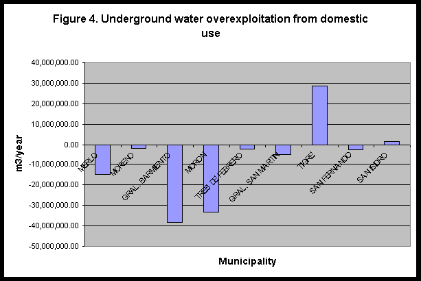
Table 3 shows the time it would take for collapse of the aquifer at current rates of domestic consumption, i.e. if population growth rates were equal to zero and no technological changes were available to increase efficiency in water use (terms in brackets are negative values, and are discarded; they correspond to those municipalities who exploit the aquifer at sustainable levels).
Table 3. Time for depletion from domestic use (years)
|
|
|
|
|
| MERLO |
170.00
|
250,466,666.10
|
16.87
|
| MORENO |
180.00
|
265,199,999.40
|
136.55
|
| GRAL. SARMIENTO |
196.00
|
288,773,332.68
|
7.52
|
| MORON |
131.00
|
193,006,666.23
|
5.79
|
| TRES DE FEBRERO |
46.00
|
67,773,333.18
|
30.87
|
| GRAL. SAN MARTIN |
56.00
|
82,506,666.48
|
15.48
|
| TIGRE |
360.00
|
530,399,998.80
|
(18.48)
|
| SAN FERNANDO |
23.00
|
33,886,666.59
|
12.83
|
| SAN ISIDRO |
48.00
|
70,719,999.84
|
(46.65)
|
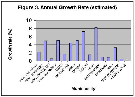
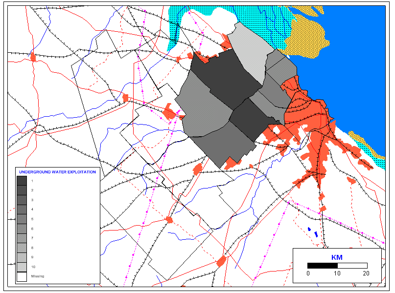
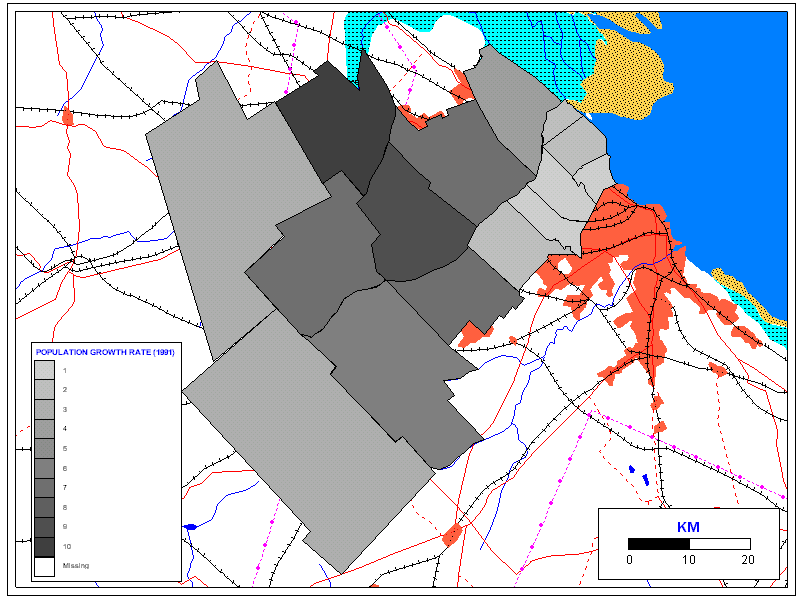
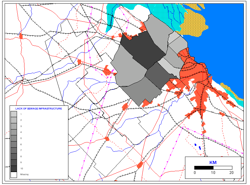
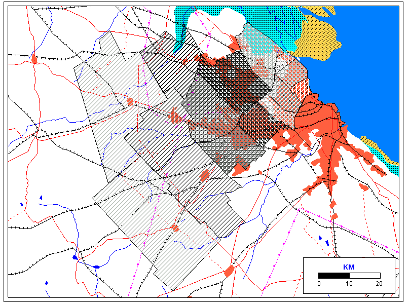
According to these results, Gral. Sarmiento and Morón would be the most immediately affected by overexploitation. Their surrounding communities would also be impacted, due to changes in the flow caused by the local depression of the aquifer. At the same time, these are the two municipalities where most of the industrial discharge flows and septic systems occur. The following figures show the risk of deterioration of groundwater resources in terms of groundwater extraction for domestic use, population growth rate, industrial discharge (relative), and septic systems, for those municipalities for which data was available.
The last map shows the overlay of these figures, in order to identify the critical areas in terms of all four variables, and confirms that Gral. Sarmiento and Morón (the darkest areas) are the most critical municipalities in the basin.
Little data is available on groundwater intake for industrial activities, which consume water in large quantities.
RECOMMENDATION FOR WATER MANAGEMENT
Water is vital for all living organisms and major ecosystems (De Sherbinin and Dompka, 1998). This includes human health, food production, and economic development for human communities. Since the first civilizations arose in the Nile, Tigris and Euphrates river basins, population growth and distribution have been intimately linked to the availability of freshwater. Today, nearly 40% of the world's food supply is grown under irrigation, and a wide variety of industrial processes depend on water. Already, humans use more than one half of all accessible surface water runoff. This proportion is expected to increase to 70% by 2025, thereby reducing the quantity and quality of water available for aquatic ecosystems. These ecosystems are critical for a range of life-supporting functions -including the cleaning and recycling of water itself. Population dynamics and water resources interact through human uses of water. The most important demographic trend affecting water resources is population growth.
According to De Sherbinin and Dompka (1998), population stabilization is vital. Population stabilization reduces pressure on water resources and serves to "buy time" for the establishment of improved water management, appropriate policies and institutional arrangements. Population growth can be slowed down by taking action in related areas of population policy, reproductive health and family planning services, and improved educational and employment opportunities for women.
Community involvement is essential for effective water management (De Sherbinin and Dompka, 1998). Because of the local nature of water-population relationships, involving communities is crucial to understanding local conditions, creating a sense of ownership, strengthening community capacity, and ensuring sustainable management of water resources.
Access to water is a human rights issue. Water is often "captured" by powerful economic interests, to the detriment of low-income people. Access to water can be viewed as a human right, as much as it is crucial for all aspects of human life (for life in general). Collaborative management of water resources may be one mechanism for improving local access, especially in irrigation schemes (De Sherbinin and Dompka, 1998).
As urban areas grow, the demand for water resources is likely to grow because urban populations, on average, use more water for domestic and industrial purposes than rural populations. On the other hand, urbanization can also present opportunities through economies of scale for more efficient and cost-effective water management (De Sherbinin and Dompka, 1998).
Public education is necessary (De Sherbinin and Dompka, 1998). Policymakers and the general public need to be educated about water resources and population dynamics, with an emphasis on making human activities sustainable with respect to water availability. Rapid in-migration of settlers is creating additional water scarcity and the lack of adequate water and sanitation infrastructure contributes to waterborne illness and other health problems. Educating settlers in water management and appropriate agricultural techniques could help to create a more sustainable relationship.
Successful approaches to balancing the needs of different sectors, stakeholders, and the environment will often involve a combination of one or more of the following strategies (De Sherbinin and Dompka, 1998):
Water is not a public good; it is a right. Groundwater is more difficult to manage than surface water because it is not seen, its dynamics is unknown and therefore is usually undervalued. The perception that water is free has caused overexploitation and pollution of the Puelche aquifer, in a context of population growth, migration, increased industrialization and urbanization.
Policies that might be applied to the river basin have to cover the areas of education and behavior patterns, economic activity, increasing the provision of sanitary services through water supply from surface waters such as the Rio de la Plata, and expansion of sewer systems. Policies should be coordinated between all the interested parties in the basin. A basin committee was already projected to operate, with community, government, and industrial representatives. Alternatives should consider the demographic transition phase that each municipality is going through, considering that growth patterns are mainly due to migration rather than to birth or death rates.
Domestic consumption can be assumed to be greater in volume than industrial consumption. In addition, population in some municipalities is projected to grow at much faster rates than industrial activity, which in turn seems to have slowed down. It can therefore be concluded that a priority should be established for domestic use of groundwater, especially because it is a basic human need. On the other hand, this same population relies on industrial activity for economic sustainability. Therefore, a compromise must be reached between total population and industrial economy, before continuing to promote indiscriminate and uncontrolled development. This would especially apply to those municipalities that are still in the initial stages of a demographic transition, i.e. with relatively low growth rates that are rapidly increasing.
A fixed price for water use has not proven successful, for which a pricing system per unit volume of water extracted might be more effective. This would give a sense of ownership, a property right that would encourage a more efficient use of the resource (The World Bank, 1998). Prices should vary according to total volumes of consumption, i.e. unit price should increase as greater volumes of water are extracted, in order to prevent economic interests from "capturing" the resource. Measurement of volumes of consumption is a primary factor for this system to work. Government efforts should focus on surveying the population and industries exploiting groundwater sources, on checking that well casings are adequate and that water extracted is from the non-polluted layers of the aquifer, and on installing measuring devices to determine volumes of extraction. Increased information and control are needed for industrial and domestic discharges that may be polluting the water resources. In addition, sewage infrastructure should be expanded to protect the groundwater from pollution, especially to areas with high population density currently lacking such systems. Charges collected from water use could be allocated to surveys and to sanitation projects.
In those municipalities with highest water deficit due to domestic overexploitation (mainly Morón and Gral. Sarmiento), consideration should also be given to expanding the water supply network covering part of the MABA to connect the denser communities and the industries. This network currently draws water from the Rio de la Plata, which has an extremely high flow but lower quality and requires treatment. This would result in lower individual costs divided among a greater population, especially compared to increasing costs of extraction of groundwater due to local depression of the aquifer. In this way, not only can the water resource be protected from overexploitation, but also from pollution caused by deficient well construction.
Recycling of gray water and use of more water use efficient technologies can also be promoted, complementing these measures.
The identification of critical areas can determine which areas to address first for the implementation of these policies. The Reconquista Basin Committee can enforce these kinds of measures in a coordinated effort between communities to manage the water resources in a sustainable manner. For these efforts to succeed, nevertheless, education of both government officials and the general public is essential to provide an understanding of how the dynamics of population and environment relate and therefore why these policies are necessary. This would bring water back as part of the integrity of the Reconquista River basin, make it visible, into something which the communities can identify with.